Сурет:Batman districts.png
Навигацияға өту
Іздеуге өту

Бұл алдын ала көрудің өлшемі: 601 × 599 пиксел. Басқа ажыратылымдықтар: 241 × 240 пиксел | 481 × 480 пиксел | 780 × 778 пиксел.
Түпнұсқа файл (780 × 778 пиксел, файл өлшемі: 18 КБ, MIME түрі: image/png)
| Бұл файл Wikimedia Commons? жобасынан, сондықтан басқа жобаларда да қолдануы мүмкін. Commons ашық лицензиялы медиа файл қоры. Сіз жобаға көмектесе аласыз. |
Ортаққордан қарау |

|
This locator map image could be re-created using vector graphics as an SVG file. This has several advantages; see Commons:Media for cleanup for more information. If an SVG form of this image is available, please upload it and afterwards replace this template with
{{vector version available|new image name}}.
It is recommended to name the SVG file “Batman districts.svg”—then the template Vector version available (or Vva) does not need the new image name parameter. |
Түйін
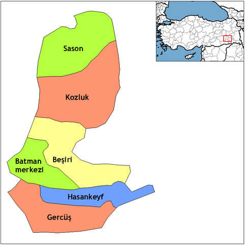
| Сипаттамасы | Map of the districts of Batman province in Turkey. Created by Rarelibra 18:55, 1 December 2006 (UTC) for public domain use, using MapInfo Professional v8.5 and various mapping resources. Edited by One Homo Sapiens Corrected text where İ,Ş,ı,ğ,or ş occurs in name. Source: [statoids-com]. Increased font size and enhanced color differences among adjacent districts. |
| Күні | 1 желтоқсан 2006 (original upload date) |
| Көзі | No machine-readable source provided. Own work assumed (based on copyright claims). |
| Авторы | No machine-readable author provided. Rarelibra assumed (based on copyright claims). |
Лицензиялау
| I, the copyright holder of this work, release this work into the public domain. This applies worldwide. In some countries this may not be legally possible; if so: I grant anyone the right to use this work for any purpose, without any conditions, unless such conditions are required by law. |
Файл тарихы
Файл сол кезде қалай көрінгенін көру үшін күн/уақыт дегенге басыңыз.
| Күн/Уақыт | Нобай | Өлшемдер | Қатысушы | Пікір | |
|---|---|---|---|---|---|
| қазіргі | 10:42, 2011 ж. ақпанның 10 | | 780 × 778 (18 КБ) | Materialscientist | crop whitespace |
| 02:00, 2008 ж. желтоқсанның 29 |  | 1056 × 816 (19 КБ) | One Homo Sapiens | Corrected text where İ,Ş,ı,ğ,or ş occurs in name. Source: [statoids-com]. Increased font size and enhanced color differences among adjacent districts. | |
| 23:55, 2006 ж. желтоқсанның 1 |  | 1056 × 816 (23 КБ) | Rarelibra | Map of the districts of Batman province in Turkey. Created by ~~~~ for public domain use, using MapInfo Professional v8.5 and various mapping resources. |
Файл қолданылуы
Бұл файлды мына бет қолданады:
Глобалды файл қолданылуы
Бұл файл келесі басқа уикилерде қолданылады:
- ar.wikipedia.org жобасында қолданылуы
- arz.wikipedia.org жобасында қолданылуы
- ast.wikipedia.org жобасында қолданылуы
- az.wikipedia.org жобасында қолданылуы
- bs.wikipedia.org жобасында қолданылуы
- ca.wikipedia.org жобасында қолданылуы
- ceb.wikipedia.org жобасында қолданылуы
- cs.wikipedia.org жобасында қолданылуы
- de.wikipedia.org жобасында қолданылуы
- diq.wikipedia.org жобасында қолданылуы
- en.wikipedia.org жобасында қолданылуы
- en.wiktionary.org жобасында қолданылуы
- eo.wikipedia.org жобасында қолданылуы
- es.wikipedia.org жобасында қолданылуы
- eu.wikipedia.org жобасында қолданылуы
- fa.wikipedia.org жобасында қолданылуы
- fi.wikipedia.org жобасында қолданылуы
- fr.wikipedia.org жобасында қолданылуы
- hr.wikipedia.org жобасында қолданылуы
Бұл файлдың глобалды қолданылуын көбірек көру.