Сурет:Kashmir map.jpg

Түпнұсқа файл (974 × 1120 пиксел, файл өлшемі: 807 КБ, MIME түрі: image/jpeg)
| Бұл файл Wikimedia Commons? жобасынан, сондықтан басқа жобаларда да қолдануы мүмкін. Commons ашық лицензиялы медиа файл қоры. Сіз жобаға көмектесе аласыз. |
Ортаққордан қарау |
Түйін
| Сипаттамасы |
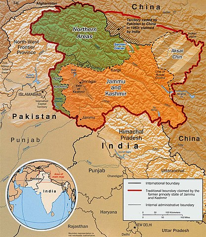
Original text from CIA World Factbook: "The Disputed Territory : Shown in green is Kashmiri region under Pakistani control. The dark-brown region represents Indian-controlled Jammu and Kashmir while the Aksai Chin is under Chinese occupation." Library of Congress, Geography and Map Division, Washington, D.C. 20540-4650 USA. Info from its archive page [1] for this map: Kashmir region. United States. Central Intelligence Agency. CREATED/PUBLISHED [Washington : Central Intelligence Agency, 2003] NOTES "763537AI (R00744) 5-03." Relief shown by shading. Shows boundaries and disputed areas. Includes location map. Scale [ca. 1:510,000]. SUBJECTS
MEDIUM 1 map : col. ; 20 x 17 cm. CALL NUMBER G7653.J3 2003 .U51 REPOSITORY Library of Congress Geography and Map Division Washington, D.C. 20540-4650 USA DIGITAL ID g7653j ct001059 http://hdl.loc.gov/loc.gmd/g7653j.ct001059 |
|||
| Күні | ||||
| Көзі |
Map is archived here: http://hdl.loc.gov/loc.gmd/g7653j.ct001059 and http://www.lib.utexas.edu/maps/middle_east_and_asia/kashmir_disputed_2003.jpg |
|||
| Авторы | Central Intelligence Agency | |||
| Рұқсат (Бұл файлды қайта қолдану) |
|
|||
| Басқа нұсқалары | العربيَّة |

Файл тарихы
Файл сол кезде қалай көрінгенін көру үшін күн/уақыт дегенге басыңыз.
| Күн/Уақыт | Нобай | Өлшемдер | Қатысушы | Пікір | |
|---|---|---|---|---|---|
| қазіргі | 13:34, 2016 ж. наурыздың 6 | | 974 × 1120 (807 КБ) | Denniss | Reverted to version as of 23:18, 6 June 2010 (UTC) |
| 04:18, 2010 ж. маусымның 7 |  | 974 × 1120 (807 КБ) | Ras67 | slightly rotated and cropped | |
| 00:55, 2007 ж. қыркүйектің 11 |  | 1029 × 1209 (310 КБ) | Timeshifter | Larger version of the same CIA map. {{PD-USGov-CIA-WF}} | |
| 13:08, 2005 ж. маусымның 13 |  | 470 × 565 (72 КБ) | Emuzesto | From en:. Original text: The Disputed Territory : Shown in green is Kashmiri region under Pakistani control. The dark-brown region represents Indian-controlled Jammu and Kashmir while the Aksai Chin is under Chinese occupati |
Файл қолданылуы
Бұл файлды мына бет қолданады:
Глобалды файл қолданылуы
Бұл файл келесі басқа уикилерде қолданылады:
- ar.wikipedia.org жобасында қолданылуы
- az.wikipedia.org жобасында қолданылуы
- bh.wikipedia.org жобасында қолданылуы
- bn.wikipedia.org жобасында қолданылуы
- bpy.wikipedia.org жобасында қолданылуы
- ca.wikipedia.org жобасында қолданылуы
- cs.wikipedia.org жобасында қолданылуы
- de.wikipedia.org жобасында қолданылуы
- el.wikipedia.org жобасында қолданылуы
- en.wikipedia.org жобасында қолданылуы
- Pakistan
- Talk:List of ongoing armed conflicts
- User talk:Vkvora2001
- Operation Meghdoot
- Saltoro Mountains
- Ghent Kangri
- Talk:India/Archive 18
- Bilafond La
- Sia La
- Portal:Maps/Maps/Political
- User:Mattisse//Maps
- Conrad O'Brien-ffrench
- Portal:Maps/Maps/Political/13
- Gyong La
- Siachen Base Camp (India)
- Actual Ground Position Line
- Talk:Azad Kashmir/Archives/2011–2012
- Chumik Glacier
- User:Sofishahidanzwalla Anantnag
- User talk:Sofishahidanzwalla Anantnag
- Saltoro Valley
- Portal:Maps
- User:Falcaorib
- 1992 India–Pakistan floods
- fa.wikipedia.org жобасында қолданылуы
- fr.wikipedia.org жобасында қолданылуы
- gl.wikipedia.org жобасында қолданылуы
- hi.wikipedia.org жобасында қолданылуы
Бұл файлдың глобалды қолданылуын көбірек көру.