Сурет:NaziGaue.png
Навигацияға өту
Іздеуге өту
Бұл алдын ала көрудің өлшемі: 698 × 600 пиксел. Басқа ажыратылымдықтар: 279 × 240 пиксел | 559 × 480 пиксел | 894 × 768 пиксел | 1224 × 1052 пиксел.
Түпнұсқа файл (1224 × 1052 пиксел, файл өлшемі: 431 КБ, MIME түрі: image/png)
| Бұл файл Wikimedia Commons? жобасынан, сондықтан басқа жобаларда да қолдануы мүмкін. Commons ашық лицензиялы медиа файл қоры. Сіз жобаға көмектесе аласыз. |
Ортаққордан қарау |
Түйін
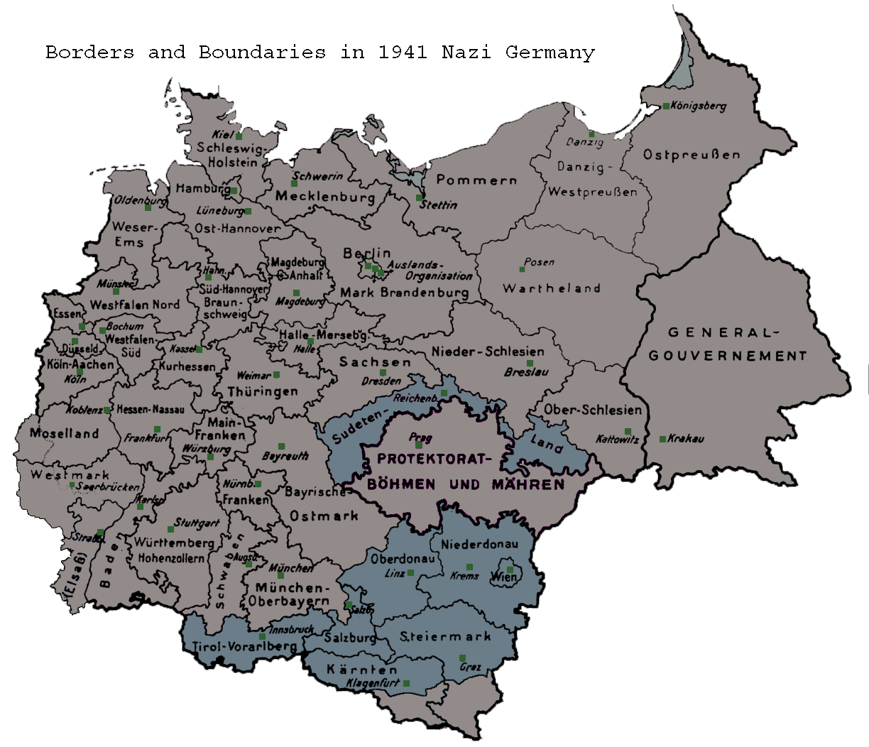
| Сипаттамасы | Map of the administrative districts in territories under the control of Nazi Germany in 1941. This map shows administration borders and has been retouched from the original Wiki Commons image. Specifically, German descriptions and titling have been eliminated. |
| Күні | 26 мамыр 2006 (original upload date) |
| Көзі | Transferred from en.wikipedia to Commons. |
| Авторы | Hohns3 at ағылшын тілі Уикипедия |
Лицензиялау
| This work has been released into the public domain by its author, Hohns3 at ағылшын тілі Уикипедия. This applies worldwide. In some countries this may not be legally possible; if so: Hohns3 grants anyone the right to use this work for any purpose, without any conditions, unless such conditions are required by law. |
Тұпнұсқа жүктеу журналы
The original description page was here. All following user names refer to en.wikipedia.
- 2006-05-26 01:08 Hohns3 1224×1052×8 (441610 bytes) Map of the administrative districts in Nazi Germany in 1941. This make shows national and political borders and has been retouched from the original Wiki Commons image. Specifically, German descriptions and titling have been eliminated.
Файл тарихы
Файл сол кезде қалай көрінгенін көру үшін күн/уақыт дегенге басыңыз.
| Күн/Уақыт | Нобай | Өлшемдер | Қатысушы | Пікір | |
|---|---|---|---|---|---|
| қазіргі | 10:39, 2007 ж. маусымның 21 | | 1224 × 1052 (431 КБ) | Moonian | {{Information |Description=Map of the administrative districts in territories under the control of Nazi Germany in 1941. This map shows administration borders and has been retouched from the original Wiki Commons image. Specifically, German descriptions |
Файл қолданылуы
Бұл файлға еш бет сілтемейді.
Глобалды файл қолданылуы
Бұл файл келесі басқа уикилерде қолданылады:
- an.wikipedia.org жобасында қолданылуы
- azb.wikipedia.org жобасында қолданылуы
- hr.wikipedia.org жобасында қолданылуы
- ka.wikipedia.org жобасында қолданылуы
- lt.wikipedia.org жобасында қолданылуы
- sh.wikipedia.org жобасында қолданылуы
- sl.wikipedia.org жобасында қолданылуы