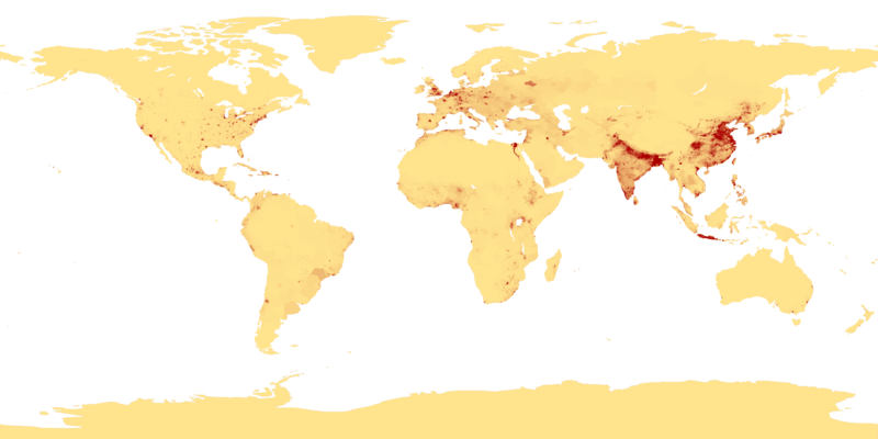
Сурет:Population density.png
Навигацияға өту
Іздеуге өту

Бұл алдын ала көрудің өлшемі: 800 × 400 пиксел. Басқа ажыратылымдықтар: 320 × 160 пиксел | 640 × 320 пиксел | 1024 × 512 пиксел | 1280 × 640 пиксел | 2560 × 1280 пиксел | 4320 × 2160 пиксел.
Түпнұсқа файл (4320 × 2160 пиксел, файл өлшемі: 522 КБ, MIME түрі: image/png)
Файл тарихы
Файл сол кезде қалай көрінгенін көру үшін күн/уақыт дегенге басыңыз.
| Күн/Уақыт | Нобай | Өлшемдер | Қатысушы | Пікір | |
|---|---|---|---|---|---|
| қазіргі | 05:41, 2013 ж. сәуірдің 11 |  | 4320 × 2160 (522 КБ) | Jahoe | Re-downloaded original from http://eoimages.gsfc.nasa.gov/images/imagerecords/53000/53005/population_density.tif, re-converted to PNG (preserving alpha channel) using tiff2png (by Willem van Schaik and Greg Roelofs). Removed rgb pixel values from fully... |
| 08:41, 2007 ж. ақпанның 27 |  | 4320 × 2160 (915 КБ) | Keenan Pepper | This image shows the number of people per square kilometer around the world in 1994. The data were derived from population records based on political divisions such as states, provinces, and counties. The image was taken from [http://visibleearth.nasa.go |
Файл қолданылуы
Бұл файлды мына 2 бет қолданады:
Глобалды файл қолданылуы
Бұл файл келесі басқа уикилерде қолданылады:
- als.wikipedia.org жобасында қолданылуы
- an.wikipedia.org жобасында қолданылуы
- ar.wikipedia.org жобасында қолданылуы
- ast.wikipedia.org жобасында қолданылуы
- az.wikipedia.org жобасында қолданылуы
- be-tarask.wikipedia.org жобасында қолданылуы
- be.wikipedia.org жобасында қолданылуы
- bg.wikipedia.org жобасында қолданылуы
- bh.wikipedia.org жобасында қолданылуы
- bn.wikipedia.org жобасында қолданылуы
- bs.wikipedia.org жобасында қолданылуы
- ca.wikipedia.org жобасында қолданылуы
- ce.wikipedia.org жобасында қолданылуы
- ckb.wikipedia.org жобасында қолданылуы
- cu.wikipedia.org жобасында қолданылуы
- cv.wikipedia.org жобасында қолданылуы
- da.wikipedia.org жобасында қолданылуы
- da.wikibooks.org жобасында қолданылуы
- de.wikipedia.org жобасында қолданылуы
- dsb.wikipedia.org жобасында қолданылуы
- el.wikipedia.org жобасында қолданылуы
- en.wikipedia.org жобасында қолданылуы
- en.wikiquote.org жобасында қолданылуы
- eo.wikipedia.org жобасында қолданылуы
- es.wikipedia.org жобасында қолданылуы
Бұл файлдың глобалды қолданылуын көбірек көру.


