Сурет:Qin empire 210 BCE.jpg
Qin_empire_210_BCE.jpg (555 × 545 пиксел, файл өлшемі: 298 КБ, MIME түрі: image/jpeg)
| Бұл файл Wikimedia Commons? жобасынан, сондықтан басқа жобаларда да қолдануы мүмкін. Commons ашық лицензиялы медиа файл қоры. Сіз жобаға көмектесе аласыз. |
Ортаққордан қарау |
Түйін
From english Wikipedia:
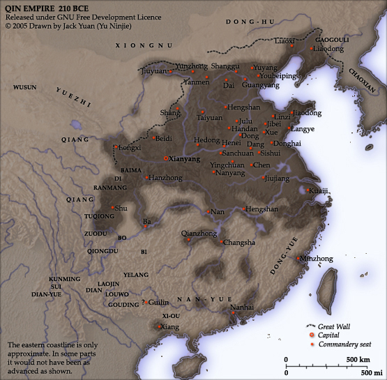
As part of his unification of China in 221 BC, Qin Shi Huang divided his empire into thirty six commanderies, each subdivided into an number of counties. The significance of the administrative reforms was its introduction of a uniformly centralised system of imperial control. The system was followed by the Han Dynasty, though with a certain degree of compromise. Thereafter, the system became the norm for later dynasties and eventually evolved into the present administrative structure of Mainland China. See: Political divisions of China.
The location of the Yellow River and commandery seats follows Tan Qixiang (ed.), Zhongguo lishi ditu (中国历史地图集), 1982. Note that the Yellow River is considerably to the north of its present flow.
The coloured territories show the approximate extent of Qin political control at the death of Qin Shi Huang in 210 BC. At that time more commanderies were added to the original thirty six, and these are also shown on the map.
Created and copyright (2005) by Yu Ninjie. Released under the GNU Free Documentation License.
Лицензиялау

|
Бұл файлды GNU Free Documentation License лицензиясының 1.2 нұсқасы бойынша немесе ескі Ашық бағдарламалық жасақтаушы қорымен жарияланған нұсқасының шарттарына сәйкес көшірмесін алуға, таратуға және/немесе өзгертуге болады. Лицензия көшірмесі GNU Free Documentation License деп аталынған бөлімде көрсетілген. |
| Бұл файл Creative Commons Attribution-Share Alike 3.0 Unported лицензиясы бойынша қолжетімді. | ||
| ||
| Лицензияландырудың бұл қасиеті осы файлға GFDL лицензиясының жаңартылуының бір бөлігі ретінде енгізілген. |
Файл тарихы
Файл сол кезде қалай көрінгенін көру үшін күн/уақыт дегенге басыңыз.
| Күн/Уақыт | Нобай | Өлшемдер | Қатысушы | Пікір | |
|---|---|---|---|---|---|
| қазіргі | 22:08, 2005 ж. қыркүйектің 2 | | 555 × 545 (298 КБ) | David.gaya | From english Wikipedia: As part of his unification of China in 221 BC, Qin Shi Huang divided his empire into thirty six commanderies, each subdivided into an number of counties. The significance of the administrative reforms wa |
Файл қолданылуы
Бұл файлды мына бет қолданады:
Глобалды файл қолданылуы
Бұл файл келесі басқа уикилерде қолданылады:
- als.wikipedia.org жобасында қолданылуы
- ar.wikipedia.org жобасында қолданылуы
- azb.wikipedia.org жобасында қолданылуы
- ba.wikipedia.org жобасында қолданылуы
- be.wikipedia.org жобасында қолданылуы
- bn.wikipedia.org жобасында қолданылуы
- ce.wikipedia.org жобасында қолданылуы
- de.wikipedia.org жобасында қолданылуы
- el.wikipedia.org жобасында қолданылуы
- en.wikipedia.org жобасында қолданылуы
- en.wikiversity.org жобасында қолданылуы
- es.wikipedia.org жобасында қолданылуы
- et.wikipedia.org жобасында қолданылуы
- fi.wikipedia.org жобасында қолданылуы
- fi.wikibooks.org жобасында қолданылуы
- frr.wikipedia.org жобасында қолданылуы
- fr.wikipedia.org жобасында қолданылуы
- fr.wikiversity.org жобасында қолданылуы
- he.wikipedia.org жобасында қолданылуы
- hu.wikipedia.org жобасында қолданылуы
- hy.wikipedia.org жобасында қолданылуы
- id.wikipedia.org жобасында қолданылуы
- ko.wikipedia.org жобасында қолданылуы
- la.wikipedia.org жобасында қолданылуы
- lt.wikipedia.org жобасында қолданылуы
- ml.wikipedia.org жобасында қолданылуы
- nl.wikipedia.org жобасында қолданылуы
- nn.wikipedia.org жобасында қолданылуы
- no.wikipedia.org жобасында қолданылуы
- pnb.wikipedia.org жобасында қолданылуы
- pt.wikibooks.org жобасында қолданылуы
- ro.wikipedia.org жобасында қолданылуы
- ru.wikipedia.org жобасында қолданылуы
Бұл файлдың глобалды қолданылуын көбірек көру.