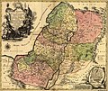
Сурет:1759 map Holy Land and 12 Tribes.jpg
Навигацияға өту
Іздеуге өту

Бұл алдын ала көрудің өлшемі: 715 × 599 пиксел. Басқа ажыратылымдықтар: 286 × 240 пиксел | 573 × 480 пиксел | 917 × 768 пиксел | 1222 × 1024 пиксел | 2000 × 1676 пиксел.
Түпнұсқа файл (2000 × 1676 пиксел, файл өлшемі: 1,74 MB, MIME түрі: image/jpeg)
Файл тарихы
Файл сол кезде қалай көрінгенін көру үшін күн/уақыт дегенге басыңыз.
| Күн/Уақыт | Нобай | Өлшемдер | Қатысушы | Пікір | |
|---|---|---|---|---|---|
| қазіргі | 16:43, 2005 ж. қыркүйектің 12 |  | 2000 × 1676 (1,74 MB) | Humus sapiens~commonswiki | 1759 map: Terra Sancta sive Palæstina exhibens no folum Regna vetera Iuda et Israel in fuas XII Tribus diftincta... Source: Library of Congress historical maps Category:Historical maps of the Middle East Category:Israel |
Файл қолданылуы
Бұл файлды мына бет қолданады:
Глобалды файл қолданылуы
Бұл файл келесі басқа уикилерде қолданылады:
- ace.wikipedia.org жобасында қолданылуы
- af.wikipedia.org жобасында қолданылуы
- anp.wikipedia.org жобасында қолданылуы
- ar.wikipedia.org жобасында қолданылуы
- ast.wikipedia.org жобасында қолданылуы
- az.wikipedia.org жобасында қолданылуы
- ba.wikipedia.org жобасында қолданылуы
- be.wikipedia.org жобасында қолданылуы
- bg.wikipedia.org жобасында қолданылуы
- bn.wikipedia.org жобасында қолданылуы
- ca.wikipedia.org жобасында қолданылуы
- crh.wikipedia.org жобасында қолданылуы
- cs.wikipedia.org жобасында қолданылуы
- cv.wikipedia.org жобасында қолданылуы
- da.wikipedia.org жобасында қолданылуы
- de.wikipedia.org жобасында қолданылуы
- de.wikisource.org жобасында қолданылуы
- diq.wikipedia.org жобасында қолданылуы
- el.wikipedia.org жобасында қолданылуы
- en.wikipedia.org жобасында қолданылуы
- en.wikiversity.org жобасында қолданылуы
- eo.wikipedia.org жобасында қолданылуы
- es.wikipedia.org жобасында қолданылуы
Бұл файлдың глобалды қолданылуын көбірек көру.
