Сурет:Breakup of Yugoslavia.gif

Уикипедия — ашық энциклопедиясынан алынған мәлімет
Навигацияға өту Іздеуге өту

Түпнұсқа файл(1545 × 1242 пиксел, файл өлшемі: 187 КБ, MIME түрі: image/gif, тұйық, 14 кадр, 44с)

Бұл файл Wikimedia Commons? жобасынан, сондықтан басқа жобаларда да қолдануы мүмкін.

Commons ашық лицензиялы медиа файл қоры. Сіз жобаға көмектесе аласыз.

Ортаққордан қарау Ортаққордан қарау
This image could be re-created using vector graphics as an SVG file. This has several advantages; see Commons:Media for cleanup for more information. If an SVG form of this image is available, please upload it and afterwards replace this template with {{vector version available|new image name}}. It is recommended to name the SVG file "Breakup of Yugoslavia.svg" - then the template Vector version available (or Vva) does not need the new image name parameter.

Түйін

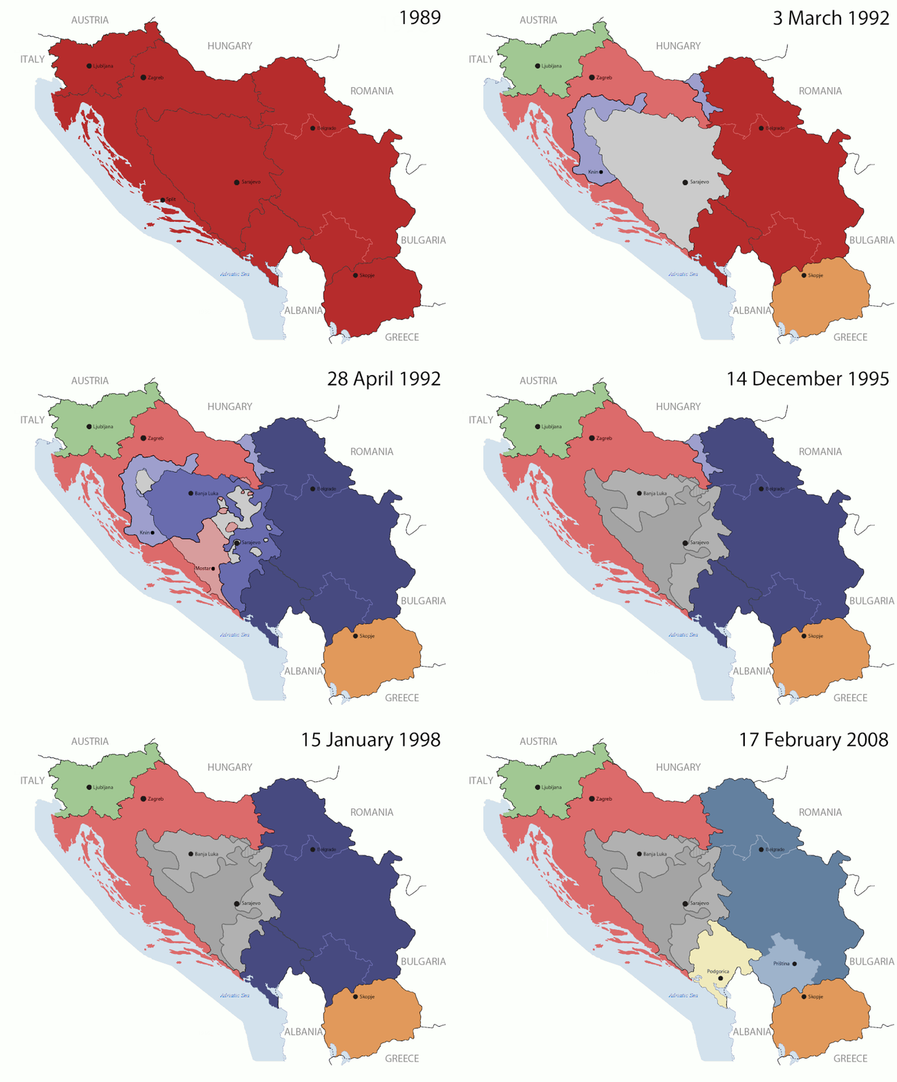
Key:

Yugoslavia (1943–1992) SFR Yugoslavia
Croatia (1991–present) Croatia
Herzeg-Bosnia (1992–1994)
UNTAES (1996–1998)
Federal Republic of Yugoslavia / Serbia and Montenegro (1992–2006) Serbia and Montenegro
Republika Srpska (1992–present) Republika Srpska
Serbian Krajina (1991–1995/96)
Republic of Bosnia and Herzegovina (1992–1995)
Bosnia and Herzegovina (1998–present) Bosnia and Herzegovina
Western Bosnia (1993–1995)
Serbia (2006–present) Serbia
Kosovo (under UNMIK control 1999–present; declaration of independence 2008) Kosovo
Montenegro (2006–present) Montenegro
Macedonia (1991–present) Macedonia
Slovenia (1991–present) Slovenia


Сипаттамасы

This is an animated GIF that shows the stages of the breakup of the SFR Yugoslavia in the 90's and 2000's. The map based off Morwen's map of the divisions of the SFRY, Which is licensed by the GFDL. The source for the dates of independence is the CIA World Factbook. These maps do not now show the Inter-Entity Boundary Line (IEBL) and/or the entities that are separated by it. The IEBL has been drawn based on this CIA map; the Brčko District has been drawn based on Image:BH municipality location.gif, by user:Ante Perkovic. I might add them in the future.

Since the original map was GFDL, this image is as well.

A map depicting Kosovo's final status is ready once it takes effect.


Changelog for versions 2/3:

Here are some changes in this new build of the map:

  • The Kosovo boundary has been given a shade of red instead of the previous UN blue since they are a province of Serbia under UNIMIK control.
  • Montenegro's color has been changed to a golden shade close to what's on the flag.
  • The IEBL and the Brčko District has been redrawn because I deleted the original map; the color for the Republika Srpska is lighter.
  • The dates are at the top left hand corner of the map instead of the bottom.
  • I have taken a new approach as to the boundaries. Each part of Yugoslavia now shows the boundary on the maps starting the year they broke away. I feel this change helps readers understand the breakup better.
  • The SFRY and the FRY are in different shades since the FRY was never accepted as the successor to the former by the UN.
  • The colors for the entities of BiH have been removed as to not confuse people into thinking that they are independent states. What remains is the IEBL with both entities in green.
  • The Kosovo boundary is finally in hash marks!
  • The Brčko District has been removed. The sale is too small to show accurately.

Changelog for version 4:

  • The map is larger!
  • The image has been rebuilt to include the eastern part of FYR Macedonia.
  • The image has been updated to take in Kosovo's new status.
  • The IEBL is now a darker line.
  • Montenegro, Kosovo, and FRY/SCG/Serbia have new colors!

Changelog for version 5:

  • Rebuilt
  • Larger map: size of base image
  • Accurate Inter-Entity Boundary Line
Күні 24 July 2006 (orginal upload date)
Көзі Made by Hoshie; see above for more details on sources.
Авторы Hoshie
Басқа нұсқалары

Лицензиялау

GNU head Бұл файлды GNU Free Documentation License лицензиясының 1.2 нұсқасы бойынша немесе ескі Ашық бағдарламалық жасақтаушы қорымен жарияланған нұсқасының шарттарына сәйкес көшірмесін алуға, таратуға және/немесе өзгертуге болады. Лицензия көшірмесі GNU Free Documentation License деп аталынған бөлімде көрсетілген.
w:en:Creative Commons
атрибуция бірдей шарттарда тарату
Бұл файл Creative Commons Attribution-Share Alike 3.0 Unported лицензиясы бойынша қолжетімді.
Сіз келесі әрекеттерге еркінсіз:
  • бөлісу – туындыны көшіру, тарату және тапсыру
  • мазмұнын өзгерту – туындыны бейімдеу
Келесі ережелерді сақтағанда:
  • атрибуция – Авторлықты белгілеп, лицензияға сілтеме беріп, өзгеріс жасалғанын анықтауыңыз керек. Сіз мұны кез келген орынды жолмен істей аласыз, бірақ лицензиар сізді немесе қолдануыңызды мақұлдайтындай емес.
  • бірдей шарттарда тарату – Материалды араластырсаңыз, түрлендірсеңіз немесе құрастырсаңыз, үлестеріңізді түпнұсқамен бірдей бірдей немесе үйлесімді лицензия бойынша таратуыңыз керек.
Лицензияландырудың бұл қасиеті осы файлға GFDL лицензиясының жаңартылуының бір бөлігі ретінде енгізілген.

Captions

Add a one-line explanation of what this file represents

Items portrayed in this file

суреттелген нәрсе

copyright status ағылшын тілі

copyrighted ағылшын тілі

MIME type ағылшын тілі

image/gif

checksum ағылшын тілі

05ca2aefea8406b809968643552d5095c847a42f

determination method ағылшын тілі: SHA-1 ағылшын тілі

data size ағылшын тілі

191 625 Байт

44 секунд

height ағылшын тілі

1242 нүкте

width ағылшын тілі

1545 нүкте

Файл тарихы

Файл сол кезде қалай көрінгенін көру үшін күн/уақыт дегенге басыңыз.

(ең жаңа | ең ескі) (жаңарақ 10  | ) (10 | 20 | 50 | 100 | 250 | 500) көру
Күн/УақытНобайӨлшемдерҚатысушыПікір
қазіргі13:40, 2016 ж. шілденің 1713:40, 2016 ж. шілденің 17 кезіндегі нұсқасының нобайы1545 × 1242 (187 КБ)מפתח-רשימהReverted to version as of 17:22, 21 August 2015 (UTC)
23:22, 2015 ж. тамыздың 2123:22, 2015 ж. тамыздың 21 кезіндегі нұсқасының нобайы1463 × 1158 (1,81 MB)BraganzaReverted to version as of 03:57, 19 January 2010
23:22, 2015 ж. тамыздың 2123:22, 2015 ж. тамыздың 21 кезіндегі нұсқасының нобайы1545 × 1242 (187 КБ)BraganzaReverted to version as of 01:02, 19 December 2011
23:15, 2015 ж. тамыздың 2123:15, 2015 ж. тамыздың 21 кезіндегі нұсқасының нобайы120 × 95 (3 КБ)Braganza03:57, 19. Jan. 2010
07:02, 2011 ж. желтоқсанның 1907:02, 2011 ж. желтоқсанның 19 кезіндегі нұсқасының нобайы1545 × 1242 (187 КБ)DIREKTORAdded details
00:09, 2011 ж. шілденің 2800:09, 2011 ж. шілденің 28 кезіндегі нұсқасының нобайы1545 × 1242 (170 КБ)DIREKTORSmall fixes
23:28, 2011 ж. шілденің 2723:28, 2011 ж. шілденің 27 кезіндегі нұсқасының нобайы1545 × 1242 (171 КБ)DIREKTORAdded UNMIK
22:38, 2011 ж. шілденің 2722:38, 2011 ж. шілденің 27 кезіндегі нұсқасының нобайы1545 × 1242 (165 КБ)DIREKTORDates for the last two frames.
18:10, 2011 ж. шілденің 2718:10, 2011 ж. шілденің 27 кезіндегі нұсқасының нобайы1545 × 1242 (149 КБ)DIREKTORLighter shade for country names
22:59, 2011 ж. шілденің 2622:59, 2011 ж. шілденің 26 кезіндегі нұсқасының нобайы1545 × 1242 (170 КБ)DIREKTORHigher res plus details
(ең жаңа | ең ескі) (жаңарақ 10  | ) (10 | 20 | 50 | 100 | 250 | 500) көру

Бұл файлды мына бет қолданады:

Глобалды файл қолданылуы

Бұл файл келесі басқа уикилерде қолданылады:

Бұл файлдың глобалды қолданылуын көбірек көру.

Метадеректер