Сурет:India literacy rate map en.svg

Түпнұсқа файл (SVG файлы, кесімді 1639 × 1852 (пиксел) нүкте, файл өлшемі: 878 КБ)
| Бұл файл Wikimedia Commons? жобасынан, сондықтан басқа жобаларда да қолдануы мүмкін. Commons ашық лицензиялы медиа файл қоры. Сіз жобаға көмектесе аласыз. |
Ортаққордан қарау |
| Тақырып |
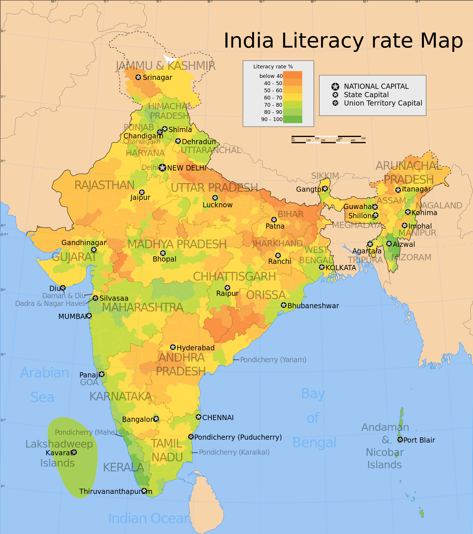
India literacy rate map (english) |
|||||||||
| Description |
Map showing the literacy rate of each district in India based on the 2001 census data. |
|||||||||
| Map legend |
 |
|||||||||
| Күні | ||||||||||
| Көзі |
Өзімнің туындым |
|||||||||
| Жасаушы | ||||||||||
| Рұқсат (Бұл файлды қайта қолдану) |
Мен бұл туындының авторымын, келесі лицензия аясында бұны жариялаймын: Бұл файл Creative Commons Attribution-Share Alike 3.0 Unported лицензиясы бойынша қолжетімді.
|
|||||||||
| Geotemporal data | ||||||||||
| Date depicted | second half of 20 century және 21 century | |||||||||
| Spatial reference system | conic | |||||||||
| Bounding box |
|
|||||||||
| Georeferencing | If inappropriate please set warp_status = skip to hide. | |||||||||
| Archival data | ||||||||||
| Ескертпелер | Part of WikiProject India Maps | |||||||||
| SVG genesis | Бұл векторлық сурет Adobe Illustrator көмегімен жасалған. |
|||||||||

Notes
Depiction of India's borders
- The territorial boundaries of India are shown as per the actual ground situation in accordance with international practices followed by the United Nations ([2], [3]) and the National Geographic Society ([4], [5])
- This map is meant to be for illustrative purpose only and is not authenticated by official government sources. Please check the list of sources and references used to create the map for a measure of accuracy and verifiability.
- The usage of these maps in India, Pakistan and China are governed by different laws that restrict depictions of boundaries other than what is officially recognized by the state. Please check local laws and modify the map accordingly before use.
Explanation of disputed boundaries


- Boundary of Indian claim : The territory India claims is legally theirs, but the claim is disputed by China and Pakistan.
- Line of Control/Line of Conflict : The de facto administrative boundary recognised by the international community. This UN ceasefire line is considered as a temporary solution to an ongoing conflict since the departure of the British Raj.
Borders of disputed regions
The depicted extent of the former territory of the British Indian Empire, succeeded by Republic of India, may not be accepted by few countries as legal due to ongoing border disputes:
- The northern Himalayan region of the disputed territory Indian-administered Kashmir is claimed by India including (Pakistan-administered Kashmir) and the Chinese-occupied territory of (Ladakh plateau). Since 1972, it is divided between all three countries. See also Line of Control and Line of Actual Control.
- Siachen glacier (shown white) is an actively contested region between India and Pakistan. Since 1984, the region is under Indian control.
- The northeastern territory of Arunachal Pradesh is almost entirely claimed by China as part of its Tibetan territory.
- Minor areas of eastern Kashmir's Ladakh division, Himachal Pradesh and Uttarakhand on the Chinese frontier are claimed by China. These areas are under Indian control.
- A small area of Uttarakhand adjoining the Nepal border along the Sarda river is disputed between the two countries.
For a detailed map of all disputed regions in South Asia, see Image:India disputed areas map.svg
Internal borders
The borders of the state of Meghalaya, Assam and Arunachal Pradesh are shown as interpreted from the North-Eastern Areas (Reorganisation) Act, 1971, but has yet to be verified.
Territorial waters
The limit of the territorial waters of India extends to twelve nautical miles measured from the appropriate baseline. See this for more information.
derivative works
Derivative works of this file: India literacy rate map he.svg
Файл тарихы
Файл сол кезде қалай көрінгенін көру үшін күн/уақыт дегенге басыңыз.
| Күн/Уақыт | Нобай | Өлшемдер | Қатысушы | Пікір | |
|---|---|---|---|---|---|
| қазіргі | 14:19, 2006 ж. қазанның 19 | | 1639 × 1852 (878 КБ) | Planemad | {{WikiProject_India_Maps |Title=India literacy rate map (english) |Description=Map showing the literacy rate of each distric in India based on the 2001 census data. |Source=Census India Map site[http://www.censusindiamaps.net] - [http://www.censusindiamap |
Файл қолданылуы
Бұл файлды мына бет қолданады:
Глобалды файл қолданылуы
Бұл файл келесі басқа уикилерде қолданылады:
- cs.wikipedia.org жобасында қолданылуы
- el.wikipedia.org жобасында қолданылуы
- en.wikipedia.org жобасында қолданылуы
- fr.wikipedia.org жобасында қолданылуы
- he.wikipedia.org жобасында қолданылуы
- hi.wikipedia.org жобасында қолданылуы
- hu.wikipedia.org жобасында қолданылуы
- kn.wikipedia.org жобасында қолданылуы
- pl.wikipedia.org жобасында қолданылуы
- ru.wikipedia.org жобасында қолданылуы
- sq.wikipedia.org жобасында қолданылуы
- tg.wikipedia.org жобасында қолданылуы
- xmf.wikipedia.org жобасында қолданылуы
- zh.wikipedia.org жобасында қолданылуы