Сурет:John-Speed-The-Kingdome-of-China-1626-2544.jpg

Түпнұсқа файл (2024 × 1640 пиксел, файл өлшемі: 3,98 MB, MIME түрі: image/jpeg)
| Бұл файл Wikimedia Commons? жобасынан, сондықтан басқа жобаларда да қолдануы мүмкін. Commons ашық лицензиялы медиа файл қоры. Сіз жобаға көмектесе аласыз. |
Ортаққордан қарау |
| Сипаттамасы |
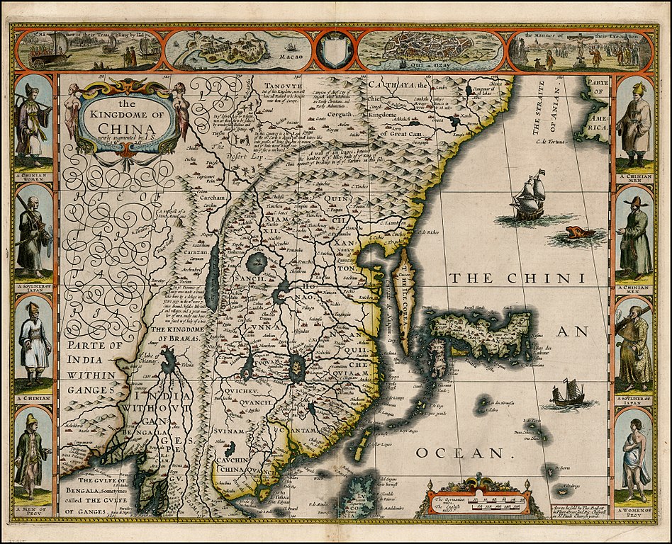
English: "The Kingdome of China", one of the first English-language maps of China. Note generally correct outline of the Ming China, with many provinces labeled (Cantam/Guangdong, Quancii/Guangxi, Chequiam/Zhejiang, Quicheu/Guizhou, Fuquam/en:Huguang/Huguang, Honao/Henan, Xanton/Shandong, Xiamxii and Sancii (Shanxi and Shaanxi?). "Xuntien alias Quinzay" more or less corresponds to Beijing (the name Shuntian Prefecture was indeed in use). However, north of China proper, John Speed had also placed "Cathaya, the Chief Kingdome of Great Cam", with the capital Cambalu (Khanbaliq - i.e., in fact, the same Beijing). This kind of duplication was common on the maps of the period, as geographers had not apparently yet fully identified Marco Polo's Cathay with the China then known to Europeans, and Cambalu with Beijing. |
|||||||||||||||||
| Күні | Originally published 1626, reprint 1627 | |||||||||||||||||
| Көзі |
English: An antique map from the Special Collection "China in Maps" of the Hong Kong University of Science and Technology Library, reproduced by the HKUST Library in the book "China in European Maps", Hong Kong, 2003. ISBN 962-86403-9-9.
Русский: Старинная карта из специальной коллекции Библиотеки Гонконгского научно-технического университета. Опубликована этой библиотекой в книге "China in European Maps" (Китай на европейских картах), Гонконг, 2003. ISBN 962-86403-9-9, тиражом 1000 экз. См. также каталог выставки, Special Collection "China in Maps".
Plate 21 |
|||||||||||||||||
| Авторы |
|
|||||||||||||||||
| Рұқсат (Бұл файлды қайта қолдану) |
Author died more than 70 years ago - public domain | |||||||||||||||||

|
Бұл туынды АҚШ-тың қоғамдық қазынасы және бұл елдерде авторлық құқық сақталу мерзімі авторы қайтыс болғанына 70 жылдан асқан немесе одан аз болады.
| |
| Бұл файл белгілі авторлық құқықтардан, сондай-ақ байланысқан және сабақтас құқықтардан еркін болып анықталған | |
Файл тарихы
Файл сол кезде қалай көрінгенін көру үшін күн/уақыт дегенге басыңыз.
| Күн/Уақыт | Нобай | Өлшемдер | Қатысушы | Пікір | |
|---|---|---|---|---|---|
| қазіргі | 18:38, 2010 ж. қаңтардың 28 | | 2024 × 1640 (3,98 MB) | Vmenkov | better scan of same map, from http://www.raremaps.com/gallery/detail/22839/the_Kingdome_of_China_newly_augmented_by_IS_1626/Speed.html |
| 06:35, 2009 ж. наурыздың 22 |  | 2560 × 1920 (2,11 MB) | Vmenkov | {{Information |Description={{en|"The Kingdome of China", one of the first English-language maps of China. Note generally correct outline of the Ming China, with many provinces labeled (Cantam/Guangdong, Quancii/Guangxi, Chequiam/Zhejiang, Quicheu/Guizhou, |
Файл қолданылуы
Бұл файлды мына бет қолданады:
Глобалды файл қолданылуы
Бұл файл келесі басқа уикилерде қолданылады:
- ar.wikipedia.org жобасында қолданылуы
- arz.wikipedia.org жобасында қолданылуы
- ast.wikipedia.org жобасында қолданылуы
- bg.wikipedia.org жобасында қолданылуы
- bn.wikipedia.org жобасында қолданылуы
- ca.wikipedia.org жобасында қолданылуы
- cv.wikipedia.org жобасында қолданылуы
- de.wikivoyage.org жобасында қолданылуы
- el.wikipedia.org жобасында қолданылуы
- en.wikipedia.org жобасында қолданылуы
- en.wikivoyage.org жобасында қолданылуы
- es.wikipedia.org жобасында қолданылуы
- eu.wikipedia.org жобасында қолданылуы
- fa.wikipedia.org жобасында қолданылуы
- fi.wikipedia.org жобасында қолданылуы
- fr.wikipedia.org жобасында қолданылуы
- he.wikipedia.org жобасында қолданылуы
- hu.wikipedia.org жобасында қолданылуы
- hy.wikipedia.org жобасында қолданылуы
- id.wikipedia.org жобасында қолданылуы
- it.wikipedia.org жобасында қолданылуы
- ko.wikipedia.org жобасында қолданылуы
- la.wikipedia.org жобасында қолданылуы
- nl.wikipedia.org жобасында қолданылуы
- nn.wikipedia.org жобасында қолданылуы
- pl.wikipedia.org жобасында қолданылуы
- pnb.wikipedia.org жобасында қолданылуы
- pt.wikipedia.org жобасында қолданылуы
- ru.wikipedia.org жобасында қолданылуы
Бұл файлдың глобалды қолданылуын көбірек көру.