Сурет:Pannoniansea currentborders.png
Навигацияға өту
Іздеуге өту

Бұл алдын ала көрудің өлшемі: 770 × 600 пиксел. Басқа ажыратылымдықтар: 308 × 240 пиксел | 617 × 480 пиксел | 986 × 768 пиксел | 1280 × 997 пиксел | 1536 × 1196 пиксел.
Түпнұсқа файл (1536 × 1196 пиксел, файл өлшемі: 119 КБ, MIME түрі: image/png)
| Бұл файл Wikimedia Commons? жобасынан, сондықтан басқа жобаларда да қолдануы мүмкін. Commons ашық лицензиялы медиа файл қоры. Сіз жобаға көмектесе аласыз. |
Ортаққордан қарау |
| Сипаттамасы |
|
| Күні | (UTC) |
| Көзі | |
| Авторы |
|
| Басқа нұсқалары | Derivative works of this file: Pannoniansea currentborders hu.png |
![[2]](https://de.wikipedia.org/w/index.php?title=Datei:Karte_Pannon_See_vor_11,5_Mio._Jahren.JPG&filetimestamp=20051220124116)
| This is a retouched picture, which means that it has been digitally altered from its original version. Modifications: borders added, legend box added. The original can be viewed here: Pannonian sea01.png:
|
Мен бұл туындының авторымын, келесі лицензия аясында бұны жариялаймын:
| I, the copyright holder of this work, release this work into the public domain. This applies worldwide. In some countries this may not be legally possible; if so: I grant anyone the right to use this work for any purpose, without any conditions, unless such conditions are required by law. |
Тұпнұсқа жүктеу журналы
This image is a derivative work of the following images:
- File:Pannonian_sea01.png licensed with PD-self
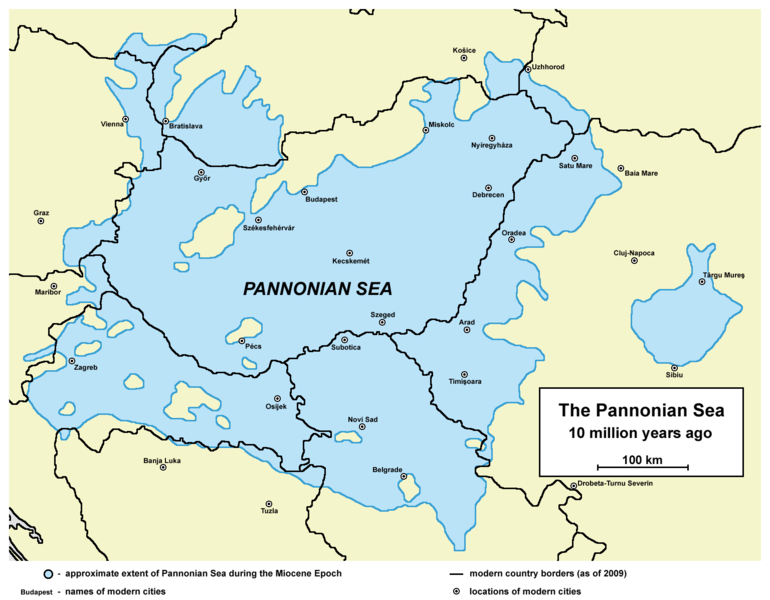
- 2009-07-11T16:19:12Z PANONIAN 1536x1196 (92896 Bytes) ==Description== * '''English:''' approximate extent of Pannonian Sea during the Miocene Epoch. * '''Serbian:''' приближне границе простирања Панонског мора током епохе миоц
Uploaded with derivativeFX
Файл тарихы
Файл сол кезде қалай көрінгенін көру үшін күн/уақыт дегенге басыңыз.
| Күн/Уақыт | Нобай | Өлшемдер | Қатысушы | Пікір | |
|---|---|---|---|---|---|
| қазіргі | 23:26, 2014 ж. ақпанның 5 | | 1536 × 1196 (119 КБ) | PANONIAN | correcting some errors as modern country borders were not fully accurate fixed on sea borders + some aesthetical improvement |
| 17:20, 2009 ж. тамыздың 23 |  | 1465 × 1061 (124 КБ) | Qorilla | date error | |
| 17:12, 2009 ж. тамыздың 23 |  | 1465 × 1061 (125 КБ) | Qorilla | {{Information |Description=* '''English:''' approximate extent of Pannonian Sea during the Miocene Epoch with modern borders and settlements '''Internet references:''' * [http://www.sulinet.hu/oroksegtar/data/telepulesek_ertekei/Ruzsa/pages/ruzsa_tortene |
Файл қолданылуы
Бұл файлды мына бет қолданады:
Глобалды файл қолданылуы
Бұл файл келесі басқа уикилерде қолданылады:
- bg.wikipedia.org жобасында қолданылуы
- el.wikipedia.org жобасында қолданылуы
- en.wikipedia.org жобасында қолданылуы
- es.wikipedia.org жобасында қолданылуы
- fr.wikipedia.org жобасында қолданылуы
- id.wikipedia.org жобасында қолданылуы
- ja.wikipedia.org жобасында қолданылуы
- ko.wikipedia.org жобасында қолданылуы
- nn.wikipedia.org жобасында қолданылуы
- no.wikipedia.org жобасында қолданылуы
- pl.wikipedia.org жобасында қолданылуы
- ro.wikipedia.org жобасында қолданылуы
- ru.wikipedia.org жобасында қолданылуы
- www.wikidata.org жобасында қолданылуы
- zh.wikipedia.org жобасында қолданылуы