Сурет:VietnameseProvincesMap.png
Түпнұсқа файл (428 × 713 пиксел, файл өлшемі: 29 КБ, MIME түрі: image/png)
| Бұл файл Wikimedia Commons? жобасынан, сондықтан басқа жобаларда да қолдануы мүмкін. Commons ашық лицензиялы медиа файл қоры. Сіз жобаға көмектесе аласыз. |
Ортаққордан қарау |

|
This locator map image could be re-created using vector graphics as an SVG file. This has several advantages; see Commons:Media for cleanup for more information. If an SVG form of this image is available, please upload it and afterwards replace this template with
{{vector version available|new image name}}.
It is recommended to name the SVG file “VietnameseProvincesMap.svg”—then the template Vector version available (or Vva) does not need the new image name parameter. |
Original at: w:Image:VietnameseProvincesMap.png, where it says:
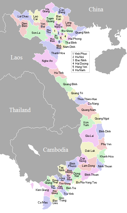
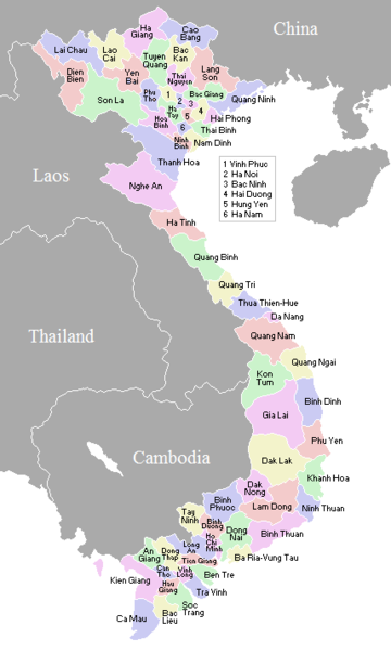
A map showing the borders and names of the Vietnamese provinces (including the changes approved in Nov 2003)
This country locator map was created by Vardion and is released into the public domain.
So this map is up to date as per current situation Waerth 07:19, 17 Mar 2005 (UTC)
See vi:Image:VietnameseProvincesMapTiengViet.png for the same map with the correctly accented Vietnamese names.
| I, the copyright holder of this work, release this work into the public domain. This applies worldwide. In some countries this may not be legally possible; if so: I grant anyone the right to use this work for any purpose, without any conditions, unless such conditions are required by law. |
en:Image:VietnameseProvincesMap.png
Файл тарихы
Файл сол кезде қалай көрінгенін көру үшін күн/уақыт дегенге басыңыз.
| Күн/Уақыт | Нобай | Өлшемдер | Қатысушы | Пікір | |
|---|---|---|---|---|---|
| қазіргі | 07:56, 2007 ж. қарашаның 2 | | 428 × 713 (29 КБ) | Vietlong | Reverted to version as of 11:41, 30 August 2006 |
| 16:47, 2006 ж. тамыздың 30 |  | 428 × 713 (25 КБ) | Vietlong | Reverted to earlier revision | |
| 16:41, 2006 ж. тамыздың 30 |  | 428 × 713 (29 КБ) | Vietlong | Correcting the boundary between Lai Chau and Lao Cai provinces | |
| 02:58, 2006 ж. қаңтардың 21 |  | 428 × 713 (25 КБ) | Vardion | correcting boundary between Dien Bien and Lai Chau provinces | |
| 10:55, 2005 ж. сәуірдің 18 |  | 428 × 713 (25 КБ) | Vardion | fixing error | |
| 12:17, 2005 ж. наурыздың 17 |  | 428 × 713 (25 КБ) | Waerth | {{PD}} |
Файл қолданылуы
Бұл файлды мына бет қолданады:
Глобалды файл қолданылуы
Бұл файл келесі басқа уикилерде қолданылады:
- ace.wikipedia.org жобасында қолданылуы
- ar.wikipedia.org жобасында қолданылуы
- ba.wikipedia.org жобасында қолданылуы
- bg.wiktionary.org жобасында қолданылуы
- blk.wikipedia.org жобасында қолданылуы
- bn.wikipedia.org жобасында қолданылуы
- ca.wikipedia.org жобасында қолданылуы
- ce.wikipedia.org жобасында қолданылуы
- da.wikipedia.org жобасында қолданылуы
- en.wikipedia.org жобасында қолданылуы
- fi.wikipedia.org жобасында қолданылуы
- gl.wikipedia.org жобасында қолданылуы
- id.wikipedia.org жобасында қолданылуы
- it.wikipedia.org жобасында қолданылуы
- krc.wikipedia.org жобасында қолданылуы
- kv.wikipedia.org жобасында қолданылуы
- lt.wikipedia.org жобасында қолданылуы
- lv.wikipedia.org жобасында қолданылуы
- map-bms.wikipedia.org жобасында қолданылуы
- ms.wikipedia.org жобасында қолданылуы
- my.wikipedia.org жобасында қолданылуы
- nl.wikipedia.org жобасында қолданылуы
- no.wikipedia.org жобасында қолданылуы
- os.wikipedia.org жобасында қолданылуы
- pam.wikipedia.org жобасында қолданылуы
- pl.wikipedia.org жобасында қолданылуы
- pt.wikipedia.org жобасында қолданылуы
- roa-tara.wikipedia.org жобасында қолданылуы
- ru.wikipedia.org жобасында қолданылуы
- su.wikipedia.org жобасында қолданылуы
- sv.wikipedia.org жобасында қолданылуы
- tr.wikipedia.org жобасында қолданылуы
Бұл файлдың глобалды қолданылуын көбірек көру.