Сурет:Yeniseirivermap.png
Навигацияға өту
Іздеуге өту
Бұл алдын ала көрудің өлшемі: 601 × 600 пиксел. Басқа ажыратылымдықтар: 240 × 240 пиксел | 481 × 480 пиксел | 988 × 986 пиксел.
Түпнұсқа файл (988 × 986 пиксел, файл өлшемі: 325 КБ, MIME түрі: image/png)
| Бұл файл Wikimedia Commons? жобасынан, сондықтан басқа жобаларда да қолдануы мүмкін. Commons ашық лицензиялы медиа файл қоры. Сіз жобаға көмектесе аласыз. |
Ортаққордан қарау |

|
This map image could be re-created using vector graphics as an SVG file. This has several advantages; see Commons:Media for cleanup for more information. If an SVG form of this image is available, please upload it and afterwards replace this template with
{{vector version available|new image name}}.
It is recommended to name the SVG file “Yeniseirivermap.svg”—then the template Vector version available (or Vva) does not need the new image name parameter. |
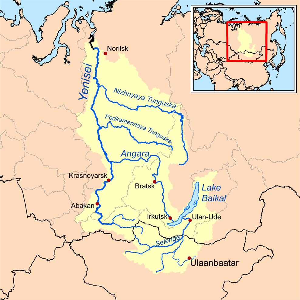
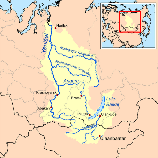
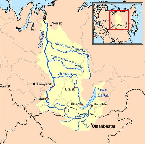
| Сипаттамасы | This is a map of the Yenisei River drainage basin, with national borders added. |
| Күні | |
| Көзі | Own work using Digital Chart of the World and GTOPO data. |
| Авторы | Kmusser |
|
|
This map image could be re-created using vector graphics as an SVG file. This has several advantages; see Commons:Media for cleanup for more information. If an SVG form of this image is available, please upload it and afterwards replace this template with
{{vector version available|new image name}}.
It is recommended to name the SVG file “Yeniseirivermap.svg”—then the template Vector version available (or Vva) does not need the new image name parameter. |
Мен бұл туындының авторымын, келесі лицензия аясында бұны жариялаймын:
Бұл файл Creative Commons Attribution-Share Alike 3.0 Unported лицензиясы бойынша қолжетімді.
- Сіз келесі әрекеттерге еркінсіз:
- бөлісу – туындыны көшіру, тарату және тапсыру
- мазмұнын өзгерту – туындыны бейімдеу
- Келесі ережелерді сақтағанда:
- атрибуция – Авторлықты белгілеп, лицензияға сілтеме беріп, өзгеріс жасалғанын анықтауыңыз керек. Сіз мұны кез келген орынды жолмен істей аласыз, бірақ лицензиар сізді немесе қолдануыңызды мақұлдайтындай емес.
- бірдей шарттарда тарату – Материалды араластырсаңыз, түрлендірсеңіз немесе құрастырсаңыз, үлестеріңізді түпнұсқамен бірдей бірдей немесе үйлесімді лицензия бойынша таратуыңыз керек.
See also
Файл тарихы
Файл сол кезде қалай көрінгенін көру үшін күн/уақыт дегенге басыңыз.
| Күн/Уақыт | Нобай | Өлшемдер | Қатысушы | Пікір | |
|---|---|---|---|---|---|
| қазіргі | 18:32, 2013 ж. қазанның 26 | | 988 × 986 (325 КБ) | Ras67 | cropped, opt. |
| 23:10, 2008 ж. қыркүйектің 15 |  | 1000 × 1000 (414 КБ) | Kmusser | {{Information |Description=This is a map of the Yenisei River drainage basin. |Source=Own work using http://www.maproom.psu.edu/dcw/ Digital Chart of the World and [[http://edc.usgs.gov/products/elevation/gtopo30/gtopo30.html GTO |
Файл қолданылуы
Бұл файлды мына бет қолданады:
Глобалды файл қолданылуы
Бұл файл келесі басқа уикилерде қолданылады:
- af.wikipedia.org жобасында қолданылуы
- am.wikipedia.org жобасында қолданылуы
- ar.wikipedia.org жобасында қолданылуы
- arz.wikipedia.org жобасында қолданылуы
- ast.wikipedia.org жобасында қолданылуы
- azb.wikipedia.org жобасында қолданылуы
- be.wikipedia.org жобасында қолданылуы
- bh.wikipedia.org жобасында қолданылуы
- bn.wikipedia.org жобасында қолданылуы
- bs.wikipedia.org жобасында қолданылуы
- ca.wikipedia.org жобасында қолданылуы
- cs.wikipedia.org жобасында қолданылуы
- cy.wikipedia.org жобасында қолданылуы
- da.wikipedia.org жобасында қолданылуы
- de.wikipedia.org жобасында қолданылуы
- en.wikipedia.org жобасында қолданылуы
- Lake Baikal
- Angara
- Yenisey
- Nizhnyaya Tunguska
- New Order (Nazism)
- Soyot
- User:Kmusser/Images
- Tungusic peoples
- Dené–Yeniseian languages
- List of Russian explorers
- Demid Pyanda
- Wikipedia:Graphics Lab/Illustration workshop/Archive/Jan 2011
- Axis powers negotiations on the division of Asia
- Physochlaina
- Yenisei Inscriptions
- eo.wikipedia.org жобасында қолданылуы
Бұл файлдың глобалды қолданылуын көбірек көру.