Сурет:John-Tallis-1851-Tibet-Mongolia-and-Manchuria-NE.jpg

Түпнұсқа файл (2100 × 1400 пиксел, файл өлшемі: 2,34 MB, MIME түрі: image/jpeg)
| Бұл файл Wikimedia Commons? жобасынан, сондықтан басқа жобаларда да қолдануы мүмкін. Commons ашық лицензиялы медиа файл қоры. Сіз жобаға көмектесе аласыз. |
Ортаққордан қарау |
| Сипаттамасы |
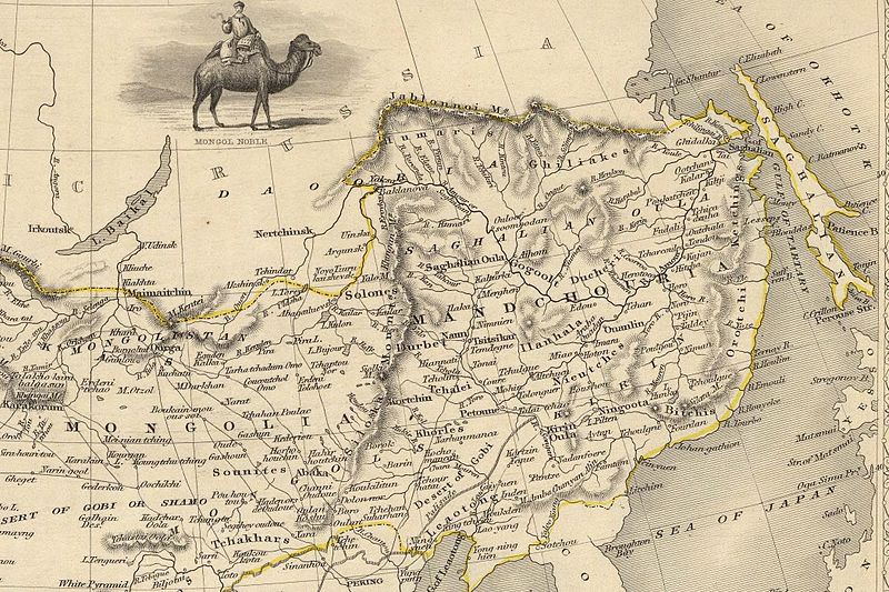
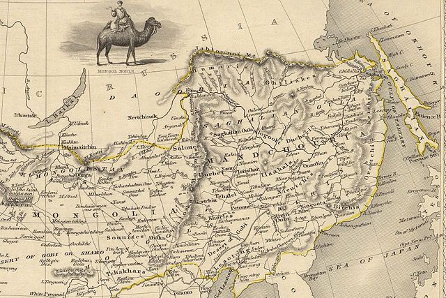
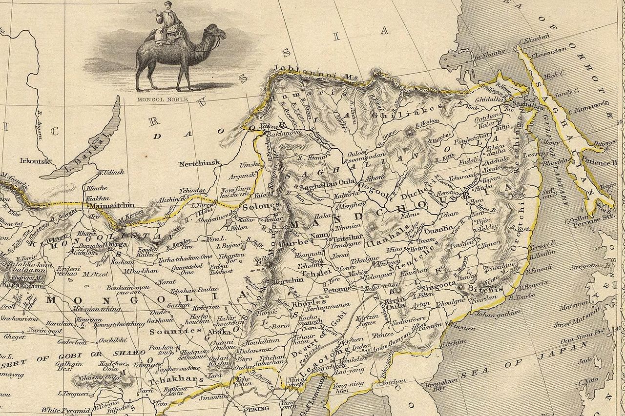
English: The NE section (Manchuria and Mongolia) of the map of the northern and western part of the Chinese Empire - "Thibet, Mongolia, and Mandchouria". The borders are shows as per the 1858 treaty of Aigun. The main Russian center in Transbaikalia is still Nerchinsk, rather than Chita. The outline of Sakhalin is already shown fairly correctly, but the body of water separating it from the mainland is still labeled "Gulf of Tartary" (rather than '"Strait). |
| Күні | (UTC) |
| Көзі | |
| Авторы |
|
| Басқа нұсқалары |
 |
| This is a retouched picture, which means that it has been digitally altered from its original version. Modifications: NE section. The original can be viewed here: John-Tallis-1851-Tibet-Mongolia-and-Manchuria-33621.jpg:
|
|
Бұл туынды АҚШ-тың қоғамдық қазынасы және бұл елдерде авторлық құқық сақталу мерзімі авторы қайтыс болғанына 70 жылдан асқан немесе одан аз болады.
| |
| Бұл файл белгілі авторлық құқықтардан, сондай-ақ байланысқан және сабақтас құқықтардан еркін болып анықталған | |
Тұпнұсқа жүктеу журналы
This image is a derivative work of the following images:
- File:John-Tallis-1851-Tibet-Mongolia-and-Manchuria-33621.jpg licensed with PD-old
- 2009-12-07T02:26:08Z Vmenkov 4700x3750 (4267392 Bytes) better resolution, as available from http://www.davidrumsey.com/luna/servlet/detail/RUMSEY~8~1~821~60126:Thibet,-Mongolia,-and-Mandchouria--
- 2009-12-07T01:38:06Z Vmenkov 1289x989 (395245 Bytes) {{Information |Description={{en|1=Map of the northern and western part of the Chinese Empire - "Thibet, Mongolia, and Mandchouria".
Uploaded with derivativeFX
Файл тарихы
Файл сол кезде қалай көрінгенін көру үшін күн/уақыт дегенге басыңыз.
| Күн/Уақыт | Нобай | Өлшемдер | Қатысушы | Пікір | |
|---|---|---|---|---|---|
| қазіргі | 08:10, 2009 ж. желтоқсанның 7 | | 2100 × 1400 (2,34 MB) | Vmenkov | {{Information |Description={{en|1=The NE section (Manchuria and Mongolia) of the map of the northern and western part of the Chinese Empire - "Thibet, Mongolia, and Mandchouria". The borders are shows as per the 1858 treaty of Aigun. The main Russian cent |
Файл қолданылуы
Бұл файлды мына бет қолданады:
Глобалды файл қолданылуы
Бұл файл келесі басқа уикилерде қолданылады:
- ar.wikipedia.org жобасында қолданылуы
- bn.wikipedia.org жобасында қолданылуы
- ca.wikipedia.org жобасында қолданылуы
- cs.wikipedia.org жобасында қолданылуы
- cv.wikipedia.org жобасында қолданылуы
- da.wikipedia.org жобасында қолданылуы
- de.wikipedia.org жобасында қолданылуы
- en.wikipedia.org жобасында қолданылуы
- en.wiktionary.org жобасында қолданылуы
- eo.wikipedia.org жобасында қолданылуы
- es.wikipedia.org жобасында қолданылуы
- fi.wikipedia.org жобасында қолданылуы
- fr.wikipedia.org жобасында қолданылуы
- hy.wikipedia.org жобасында қолданылуы
- id.wikipedia.org жобасында қолданылуы
- it.wikipedia.org жобасында қолданылуы
- ja.wikipedia.org жобасында қолданылуы
- ka.wikipedia.org жобасында қолданылуы
- ko.wikipedia.org жобасында қолданылуы
- la.wikipedia.org жобасында қолданылуы
- lt.wikipedia.org жобасында қолданылуы
- mn.wikipedia.org жобасында қолданылуы
- no.wikipedia.org жобасында қолданылуы
- pl.wikipedia.org жобасында қолданылуы
Бұл файлдың глобалды қолданылуын көбірек көру.