Сурет:Kerguelen Map.png
Навигацияға өту
Іздеуге өту

Бұл алдын ала көрудің өлшемі: 618 × 600 пиксел. Басқа ажыратылымдықтар: 247 × 240 пиксел | 495 × 480 пиксел | 791 × 768 пиксел | 1055 × 1024 пиксел | 1964 × 1906 пиксел.
Түпнұсқа файл (1964 × 1906 пиксел, файл өлшемі: 337 КБ, MIME түрі: image/png)
| Бұл файл Wikimedia Commons? жобасынан, сондықтан басқа жобаларда да қолдануы мүмкін. Commons ашық лицензиялы медиа файл қоры. Сіз жобаға көмектесе аласыз. |
Ортаққордан қарау |

|
This map image could be re-created using vector graphics as an SVG file. This has several advantages; see Commons:Media for cleanup for more information. If an SVG form of this image is available, please upload it and afterwards replace this template with
{{vector version available|new image name}}.
It is recommended to name the SVG file “Kerguelen Map.svg”—then the template Vector version available (or Vva) does not need the new image name parameter. |
| Сипаттамасы |
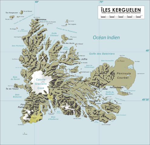
English: Map of the Kerguelen Islands, French Southern and Antarctic Territories
Deutsch: Karte des Kerguelen-Archipel |
||
| Күні | 8 сәуір 2006 (original upload date) | ||
| Көзі | Өзімнің туындым | ||
| Авторы | Varp | ||
| Рұқсат (Бұл файлды қайта қолдану) |
|
Файл тарихы
Файл сол кезде қалай көрінгенін көру үшін күн/уақыт дегенге басыңыз.
| Күн/Уақыт | Нобай | Өлшемдер | Қатысушы | Пікір | |
|---|---|---|---|---|---|
| қазіргі | 18:04, 2008 ж. қазанның 16 | | 1964 × 1906 (337 КБ) | Ralf Roletschek | {{Information |Description= |Source= |Date= |Author= |Permission= |other_versions= }} |
| 12:40, 2006 ж. сәуірдің 13 |  | 1964 × 1906 (904 КБ) | Varp~commonswiki | ||
| 12:41, 2006 ж. сәуірдің 12 |  | 1964 × 1906 (866 КБ) | Varp~commonswiki | ||
| 15:14, 2006 ж. сәуірдің 9 |  | 1964 × 1906 (866 КБ) | Varp~commonswiki | ||
| 19:52, 2006 ж. сәуірдің 8 |  | 1964 × 1906 (853 КБ) | Varp~commonswiki | *Map of the Kerguelen Islands, French Southern and Antarctic Territories *drawn by varp |
Файл қолданылуы
Бұл файлға еш бет сілтемейді.
Глобалды файл қолданылуы
Бұл файл келесі басқа уикилерде қолданылады:
- als.wikipedia.org жобасында қолданылуы
- ar.wikipedia.org жобасында қолданылуы
- da.wikipedia.org жобасында қолданылуы
- de.wikipedia.org жобасында қолданылуы
- de.wikivoyage.org жобасында қолданылуы
- de.wiktionary.org жобасында қолданылуы
- el.wikipedia.org жобасында қолданылуы
- en.wikipedia.org жобасында қолданылуы
- es.wikipedia.org жобасында қолданылуы
- et.wikipedia.org жобасында қолданылуы
- frr.wikipedia.org жобасында қолданылуы
- fr.wikipedia.org жобасында қолданылуы
- gag.wikipedia.org жобасында қолданылуы
- gl.wikipedia.org жобасында қолданылуы
- hr.wikipedia.org жобасында қолданылуы
- hu.wikipedia.org жобасында қолданылуы
- id.wikipedia.org жобасында қолданылуы
- ie.wikipedia.org жобасында қолданылуы
- is.wikipedia.org жобасында қолданылуы
- ka.wikipedia.org жобасында қолданылуы
- lt.wikipedia.org жобасында қолданылуы
- nds.wikipedia.org жобасында қолданылуы
- nn.wikipedia.org жобасында қолданылуы
- no.wikipedia.org жобасында қолданылуы
- pl.wikipedia.org жобасында қолданылуы
- pnb.wikipedia.org жобасында қолданылуы
- ro.wikipedia.org жобасында қолданылуы
- sk.wikipedia.org жобасында қолданылуы
- sr.wikipedia.org жобасында қолданылуы
- sv.wikipedia.org жобасында қолданылуы
- ug.wikipedia.org жобасында қолданылуы
- uk.wikipedia.org жобасында қолданылуы
- ur.wikipedia.org жобасында қолданылуы
- vi.wikipedia.org жобасында қолданылуы
- war.wikipedia.org жобасында қолданылуы
- zh.wikipedia.org жобасында қолданылуы