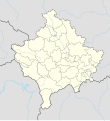
Сурет:Kosovo adm location map.svg

Уикипедия — ашық энциклопедиясынан алынған мәлімет
Навигацияға өту Іздеуге өту

Түпнұсқа файл(SVG файлы, кесімді 1014 × 1109 (пиксел) нүкте, файл өлшемі: 185 КБ)

Бұл файл Wikimedia Commons? жобасынан, сондықтан басқа жобаларда да қолдануы мүмкін.

Commons ашық лицензиялы медиа файл қоры. Сіз жобаға көмектесе аласыз.

Ортаққордан қарау Ортаққордан қарау

Түйін

Сипаттамасы
Deutsch: Positionskarte des Kosovo
English: Location map of Kosovo

Equirectangular projection, vertical stretching 135 %
Border coordinates

43.3
19.8←↕→21.9
41.7
 Анықтама үшін This map is part of a series of location maps with unified standards: SVG as file format, standardised colours and name scheme. The boundaries on these maps always show the de facto situation and do not imply any endorsement or acceptance. In case of changes of the shown area the file is updated. The old version will be uploaded as a new file and thus is still available.
Күні
Көзі

Own work using:

  • United States National Imagery and Mapping Agency data
Авторы NordNordWest
Басқа нұсқалары
SVG genesis
InfoField
 
Бұл SVG-файлдың бастапқы коды дұрыс.
 
Бұл векторлық сурет Adobe Illustrator көмегімен жасалған.
Kartenwerkstatt
This SVG map has been made or improved in the German Kartenwerkstatt (Map Lab). You can propose maps to improve as well.

Лицензиялау

Usage of this file with:

explanatory notes: Legally binding is only the full legalcode. For a free usage I recommend to respect the following licence conditions:
1. Provide my name as given above: NordNordWest,
2. a copy of, or the URI for, the applicable license: https://creativecommons.org/licenses/by-sa/3.0/de/legalcode,
3. the title of the work,
4. in the case of an adaptation, a credit identifying the use of the work in the adaptation.
This license and the rights granted hereunder will terminate automatically upon any breach by you of the terms of this license. Any of the above conditions can be waived if you get permission from the copyright holder. If you have questions or wish differing conditions, please contact me through nnwest@t-online.de or my discussion page

w:en:Creative Commons
атрибуция бірдей шарттарда тарату
Бұл файл Creative Commons Attribution-Share Alike 3.0 Germany лицензиясы бойынша қолжетімді.
Атрибуция: Karte: NordNordWest, Lizenz: Creative Commons by-sa-3.0 de
Сіз келесі әрекеттерге еркінсіз:
  • бөлісу – туындыны көшіру, тарату және тапсыру
  • мазмұнын өзгерту – туындыны бейімдеу
Келесі ережелерді сақтағанда:
  • атрибуция – Авторлықты белгілеп, лицензияға сілтеме беріп, өзгеріс жасалғанын анықтауыңыз керек. Сіз мұны кез келген орынды жолмен істей аласыз, бірақ лицензиар сізді немесе қолдануыңызды мақұлдайтындай емес.
  • бірдей шарттарда тарату – Материалды араластырсаңыз, түрлендірсеңіз немесе құрастырсаңыз, үлестеріңізді түпнұсқамен бірдей бірдей немесе үйлесімді лицензия бойынша таратуыңыз керек.

Captions

Add a one-line explanation of what this file represents

Items portrayed in this file

суреттелген нәрсе

copyright status ағылшын тілі

copyrighted ағылшын тілі

copyright license ағылшын тілі

inception ағылшын тілі

12 қаңтар, 2018

Файл тарихы

Файл сол кезде қалай көрінгенін көру үшін күн/уақыт дегенге басыңыз.

Күн/УақытНобайӨлшемдерҚатысушыПікір
қазіргі23:29, 2020 ж. наурыздың 1723:29, 2020 ж. наурыздың 17 кезіндегі нұсқасының нобайы1014 × 1109 (185 КБ)NordNordWestReverted to version as of 13:31, 16 March 2018 (UTC), not without a discussion
17:15, 2020 ж. наурыздың 1717:15, 2020 ж. наурыздың 17 кезіндегі нұсқасының нобайы512 × 560 (119 КБ)ZvuqnikiReverted to version as of 13:09, 16 March 2018 (UTC)
17:12, 2020 ж. наурыздың 1717:12, 2020 ж. наурыздың 17 кезіндегі нұсқасының нобайы1014 × 1109 (210 КБ)ZvuqnikiThis map reflects the current reality regarding the border of Kosovo. Serbia has no authority over Kosovo, and there are police and military forces that all Kosovo borders.
18:31, 2018 ж. наурыздың 1618:31, 2018 ж. наурыздың 16 кезіндегі нұсқасының нобайы1014 × 1109 (185 КБ)NordNordWestReverted to version as of 18:29, 12 January 2018 (UTC) Serbia still thinks that Kosovo is part of Serbia, so it stays with a dashed line
18:09, 2018 ж. наурыздың 1618:09, 2018 ж. наурыздың 16 кезіндегі нұсқасының нобайы512 × 560 (119 КБ)HakuliKosovo new map updatet. The dashlines are removed. The dashlines are used only when is shown a larger map.
23:29, 2018 ж. қаңтардың 1223:29, 2018 ж. қаңтардың 12 кезіндегі нұсқасының нобайы1014 × 1109 (185 КБ)NordNordWest== {{int:filedesc}} == {{Information |Description= {{de|1=Positionskarte des Kosovo}} {{en|1=Location map of Kosovo}} {{Location map series N |stretching=135 |top=43.3 |bottom=41.7 |left=19.8 |right=21.9 }} |Source={{Own using}} * United States Nationa...

Бұл файлды мына 3 бет қолданады:

Глобалды файл қолданылуы

Бұл файл келесі басқа уикилерде қолданылады:

Бұл файлдың глобалды қолданылуын көбірек көру.

Метадеректер