Сурет:Maine state capitol.jpg

Түпнұсқа файл (1500 × 2000 пиксел, файл өлшемі: 1,26 MB, MIME түрі: image/jpeg)
| Бұл файл Wikimedia Commons? жобасынан, сондықтан басқа жобаларда да қолдануы мүмкін. Commons ашық лицензиялы медиа файл қоры. Сіз жобаға көмектесе аласыз. |
Ортаққордан қарау |
|
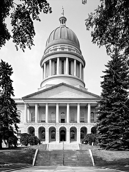
This is an image of a place or building that is listed on the National Register of Historic Places in the United States of America. Its reference number is 73000266. |
Maine State House, State & Capitol Streets, Augusta, Kennebec County, ME
Main (South) elevation
August 1965
- Photographer
- Jack E. Boucher
- Original file
- 17MB TIFF file, corrected, cropped, denoised, converted to JPEG

|
This file comes from the Historic American Buildings Survey (HABS), Historic American Engineering Record (HAER) or Historic American Landscapes Survey (HALS). These are programs of the National Park Service established for the purpose of documenting historic places. Records consist of measured drawings, archival photographs, and written reports.
|
| This image or media file contains material based on a work of a National Park Service employee, created as part of that person's official duties. As a work of the U.S. federal government, such work is in the public domain in the United States. See the NPS website and NPS copyright policy for more information. |
| Object location | | View this and other nearby images on: OpenStreetMap |
|---|
Файл тарихы
Файл сол кезде қалай көрінгенін көру үшін күн/уақыт дегенге басыңыз.
| Күн/Уақыт | Нобай | Өлшемдер | Қатысушы | Пікір | |
|---|---|---|---|---|---|
| қазіргі | 12:13, 2005 ж. ақпанның 4 | | 1500 × 2000 (1,26 MB) | MarkSweep | Maine state capitol {{HABS}} |
Файл қолданылуы
Бұл файлды мына бет қолданады:
Глобалды файл қолданылуы
Бұл файл келесі басқа уикилерде қолданылады:
- bg.wikipedia.org жобасында қолданылуы
- da.wikipedia.org жобасында қолданылуы
- de.wikipedia.org жобасында қолданылуы
- el.wikipedia.org жобасында қолданылуы
- en.wikipedia.org жобасында қолданылуы
- en.wikivoyage.org жобасында қолданылуы
- es.wikipedia.org жобасында қолданылуы
- fa.wikipedia.org жобасында қолданылуы
- fi.wikipedia.org жобасында қолданылуы
- fo.wikipedia.org жобасында қолданылуы
- fr.wikipedia.org жобасында қолданылуы
- gl.wikipedia.org жобасында қолданылуы
- he.wikipedia.org жобасында қолданылуы
- hy.wikipedia.org жобасында қолданылуы
- it.wikipedia.org жобасында қолданылуы
- ja.wikipedia.org жобасында қолданылуы
- ko.wikipedia.org жобасында қолданылуы
- lmo.wikipedia.org жобасында қолданылуы
- mi.wikipedia.org жобасында қолданылуы
- nl.wikipedia.org жобасында қолданылуы
- pl.wikipedia.org жобасында қолданылуы
- pnb.wikipedia.org жобасында қолданылуы
- pt.wikipedia.org жобасында қолданылуы
- ro.wikipedia.org жобасында қолданылуы
- ru.wikipedia.org жобасында қолданылуы
- www.wikidata.org жобасында қолданылуы
- zh.wikipedia.org жобасында қолданылуы