Сурет:Sweden CIA map extended.gif
Түпнұсқа файл (300 × 714 пиксел, файл өлшемі: 21 КБ, MIME түрі: image/gif)
| Бұл файл Wikimedia Commons? жобасынан, сондықтан басқа жобаларда да қолдануы мүмкін. Commons ашық лицензиялы медиа файл қоры. Сіз жобаға көмектесе аласыз. |
Ортаққордан қарау |
Түйін
| Сипаттамасы |
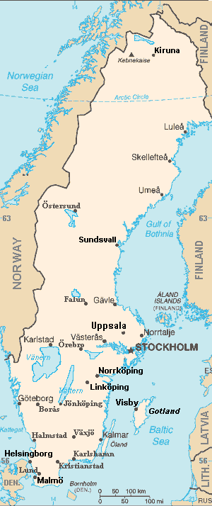
Map of Sweden, extended from CIA World Fact Book, showing largest cities, islands and lake names. Larger city names (10) have been labeled with font-face Arial or Arial Narrow, as font-size 9 or 10; the island/region names are labeled in italic font. Sweden contains over 200 towns, but they are evenly dispersed around the main southern towns, except near Copenhagen, which has very high density. This map has locator code "SwedenCIAx" for use in map-locator templates, such as English Wiki Template:Location_map_SwedenCIAx & Template:Location_map_skew (which skews northern coordinates for multiple map markers/labels). The latitude/longitude coordinates are not equirectangular, but rather, narrow at the north, with longitudes about 38% closer together at the top. The narrowing longitudes provide more accurate mapping of area and distance than with rectangular coordinates. The original map image was public domain; the following modifications have been made to the original:
|
| Күні | |
| Көзі | Derivative of map from User:Fred_J changing CIA map (Wikimedia Commons): Image:Sweden from cia.png (adding 10 labels, restoring color to CIA hues & magnified 15%) |
| Авторы | Wikid77 (derivative of User:Fred_J form of CIA map, adding 10 labels) |
| Басқа нұсқалары |
This map has some variations:
|
Лицензиялау
- Сіз келесі әрекеттерге еркінсіз:
- бөлісу – туындыны көшіру, тарату және тапсыру
- мазмұнын өзгерту – туындыны бейімдеу
- Келесі ережелерді сақтағанда:
- атрибуция – Авторлықты белгілеп, лицензияға сілтеме беріп, өзгеріс жасалғанын анықтауыңыз керек. Сіз мұны кез келген орынды жолмен істей аласыз, бірақ лицензиар сізді немесе қолдануыңызды мақұлдайтындай емес.
- бірдей шарттарда тарату – If you alter, transform, or build upon this work, you must distribute the resulting work under the same license as the original.
This image is in the public domain because it contains materials that originally came from the United States Central Intelligence Agency's World Factbook.
|
 |
Format

This file is purposely maintained in GIF format (most international GIF-related patents have expired) for compatibility with the original CIA maps. Semi-automatic conversions to PNG-format might lose the color hues of the CIA maps, tending to shift to lighter blue and shift beige to white. A larger, detailed version of the map is being expanded, with more of the smaller 200 towns added.
Файл тарихы
Файл сол кезде қалай көрінгенін көру үшін күн/уақыт дегенге басыңыз.
| Күн/Уақыт | Нобай | Өлшемдер | Қатысушы | Пікір | |
|---|---|---|---|---|---|
| қазіргі | 23:44, 2007 ж. қыркүйектің 5 | | 300 × 714 (21 КБ) | Wikid77 | completed east border of Sweden; enlarged "Helsingborg" & "Malmo" etc. |
| 17:33, 2007 ж. қыркүйектің 5 |  | 300 × 714 (21 КБ) | Wikid77 | ==Summary== {{Information | Description= Map of Sweden, from CIA World Fact Book, with extensions for more town names and lakes. The original map image was public domain; the following modifications have been made to the original: * Drawing in lakes [[w:V |
Файл қолданылуы
Бұл файлды мына бет қолданады:
Глобалды файл қолданылуы
Бұл файл келесі басқа уикилерде қолданылады:
- ar.wikipedia.org жобасында қолданылуы
- bn.wikipedia.org жобасында қолданылуы
- en.wikipedia.org жобасында қолданылуы
- User:Wikid77/Template:Location map skew
- User:Wikid77/Template:Location map skew/doc
- User:Wikid77/Template:Location map polarx
- User:Wikid77/Template:Location map polarx/doc
- User:Wikid77/Template:Location map SwedenCIAx
- Module talk:Location map/data/Sweden
- User:Wikid77/Template:Location map SwedenCIAskew
- kn.wikipedia.org жобасында қолданылуы
- ky.wikipedia.org жобасында қолданылуы
- mrj.wikipedia.org жобасында қолданылуы
- no.wikipedia.org жобасында қолданылуы
- ru.wikipedia.org жобасында қолданылуы
- uk.wikipedia.org жобасында қолданылуы
- yo.wikipedia.org жобасында қолданылуы