Сурет:TorresStraitIslandsMap.png
Навигацияға өту
Іздеуге өту

Бұл алдын ала көрудің өлшемі: 604 × 599 пиксел. Басқа ажыратылымдықтар: 242 × 240 пиксел | 484 × 480 пиксел | 929 × 922 пиксел.
Түпнұсқа файл (929 × 922 пиксел, файл өлшемі: 28 КБ, MIME түрі: image/png)
| Бұл файл Wikimedia Commons? жобасынан, сондықтан басқа жобаларда да қолдануы мүмкін. Commons ашық лицензиялы медиа файл қоры. Сіз жобаға көмектесе аласыз. |
Ортаққордан қарау |
Түйін

|
This locator map image could be re-created using vector graphics as an SVG file. This has several advantages; see Commons:Media for cleanup for more information. If an SVG form of this image is available, please upload it and afterwards replace this template with
{{vector version available|new image name}}.
It is recommended to name the SVG file “TorresStraitIslandsMap.svg”—then the template Vector version available (or Vva) does not need the new image name parameter. |
| Сипаттамасы |
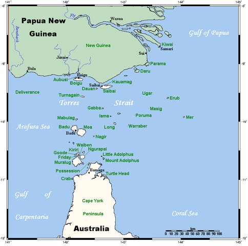
A map of the Torres Strait Islands. I have endeavoured to use native names wherever I could find them. If you can suggest ways in which this map could be made more up to date, don't hesitate to leave me a message to that effect. This map's source is here, with the uploader's modifications, and the GMT homepage says that the tools are released under the GNU General Public License. |
| Күні | 18 сәуір 2006 (original upload date) |
| Көзі | Transferred from en.wikipedia to Commons. |
| Авторы | Kelisi at ағылшын тілі Уикипедия |
| Басқа нұсқалары | Image:TorresStraitIslandsMap (zh).png |
.png)
Лицензиялау
Kelisi from en.wikipedia.org, the copyright holder of this work, hereby publishes it under the following license:
| Бұл файл Creative Commons Attribution-Share Alike 3.0 Unported лицензиясы бойынша қолжетімді. Subject to disclaimers. | ||
| Атрибуция: Kelisi from en.wikipedia.org | ||
| ||
| Лицензияландырудың бұл қасиеті осы файлға GFDL лицензиясының жаңартылуының бір бөлігі ретінде енгізілген. |

|
Бұл файлды GNU Free Documentation License лицензиясының 1.2 нұсқасы бойынша немесе ескі Ашық бағдарламалық жасақтаушы қорымен жарияланған нұсқасының шарттарына сәйкес көшірмесін алуға, таратуға және/немесе өзгертуге болады. Лицензия көшірмесі GNU Free Documentation License деп аталынған бөлімде көрсетілген. Subject to disclaimers. |
Тұпнұсқа жүктеу журналы
The original description page was here. All following user names refer to en.wikipedia.
- 2006-04-19 00:55 Kelisi 929×922×8 (28510 bytes)
- 2006-04-18 03:38 Kelisi 929×922×8 (28133 bytes) A map of the Torres Strait Islands. I have endeavoured to use native names wherever I could find them. If you can suggest ways in which this map could be made more up to date, don't hesitate to leave me a message to that effect. This map's source is [htt
Файл тарихы
Файл сол кезде қалай көрінгенін көру үшін күн/уақыт дегенге басыңыз.
| Күн/Уақыт | Нобай | Өлшемдер | Қатысушы | Пікір | |
|---|---|---|---|---|---|
| қазіргі | 11:42, 2022 ж. қаңтардың 13 | | 929 × 922 (28 КБ) | Kelisi | Reverted to version as of 00:09, 1 May 2007 (UTC) Hardly; those two colours are closer to each other. |
| 22:59, 2021 ж. қазанның 6 |  | 929 × 922 (31 КБ) | Claude Zygiel | Better contrast | |
| 05:09, 2007 ж. мамырдың 1 |  | 929 × 922 (28 КБ) | Stanmar | {{Information |Description=A map of the Torres Strait Islands. I have endeavoured to use native names wherever I could find them. If you can suggest ways in which this map could be made more up to date, don't hesitate to leave me a message to that effect. |
Файл қолданылуы
Бұл файлды мына бет қолданады:
Глобалды файл қолданылуы
Бұл файл келесі басқа уикилерде қолданылады:
- af.wikipedia.org жобасында қолданылуы
- als.wikipedia.org жобасында қолданылуы
- ar.wikipedia.org жобасында қолданылуы
- azb.wikipedia.org жобасында қолданылуы
- ba.wikipedia.org жобасында қолданылуы
- bg.wikipedia.org жобасында қолданылуы
- bn.wikipedia.org жобасында қолданылуы
- br.wikipedia.org жобасында қолданылуы
- ca.wikipedia.org жобасында қолданылуы
- ceb.wikipedia.org жобасында қолданылуы
- cs.wikipedia.org жобасында қолданылуы
- cy.wikipedia.org жобасында қолданылуы
- da.wikipedia.org жобасында қолданылуы
- de.wikipedia.org жобасында қолданылуы
- Torres-Straße
- Prince-of-Wales-Insel (Queensland)
- Torres-Straits-Expedition
- Bellevue-Inseln
- Mabuiag
- Talbot-Inseln
- Boigu
- Flagge der Torres-Strait-Insulaner
- Manar-Inseln
- Thursday Island
- Horn Island (Torres Strait)
- Saibai
- Thursday-Inseln
- The Three Sisters (Torres Strait)
- Dauan
- Bet Island
- Poll Island
- Sue Island
- Murray-Inseln
- Murray Island
- Badu Island
- Moa Island
- Coconut Island (Australien)
- Yam Island
- Hammond Island
- Goods Island
- Friday Island (Torres Strait)
Бұл файлдың глобалды қолданылуын көбірек көру.