Сурет:München - Stadtbezirke (Karte).png
Түпнұсқа файл (2119 × 1641 пиксел, файл өлшемі: 338 КБ, MIME түрі: image/png)
| Бұл файл Wikimedia Commons? жобасынан, сондықтан басқа жобаларда да қолдануы мүмкін. Commons ашық лицензиялы медиа файл қоры. Сіз жобаға көмектесе аласыз. |
Ортаққордан қарау |
Articles about the boroughs of Munich in the German Wikipedia (original list)
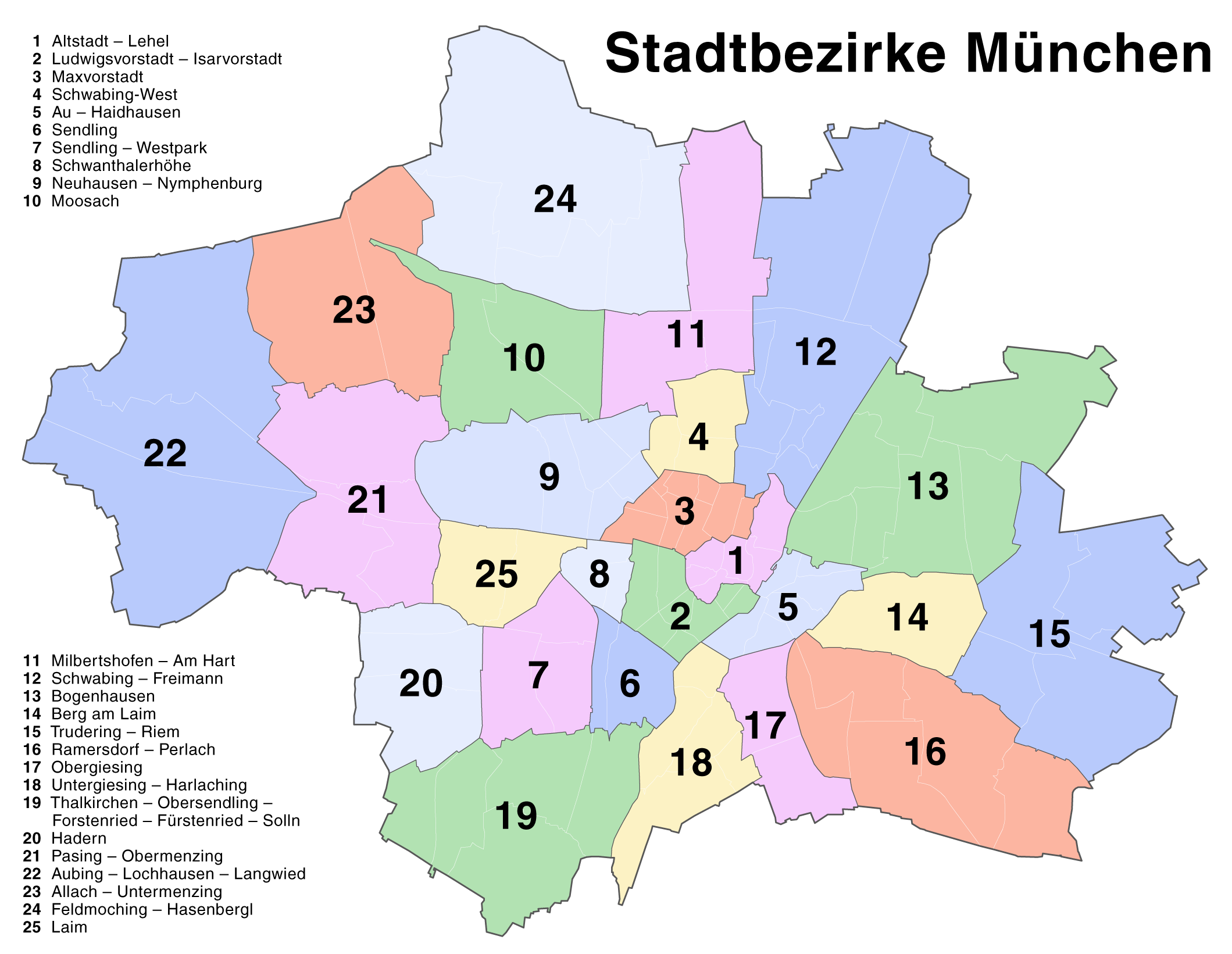
23 Allach-Untermenzing - 1 Altstadt-Lehel - 22 Aubing-Lochhausen-Langwied - 5 Au-Haidhausen - 14 Berg am Laim - 13 Bogenhausen - 24 Feldmoching-Hasenbergl - 20 Hadern - 25 Laim - 2 Ludwigsvorstadt-Isarvorstadt - 3 Maxvorstadt - 11 Milbertshofen-Am Hart - 10 Moosach - 9 Neuhausen-Nymphenburg - 17 Obergiesing - 21 Pasing-Obermenzing - 16 Ramersdorf-Perlach - 12 Schwabing-Freimann - 4 Schwabing-West - 8 Schwanthalerhöhe - 6 Sendling - 7 Sendling-Westpark - 19 Thalkirchen-Obersendling-Forstenried-Fürstenried-Solln - 15 Trudering-Riem - 18 Untergiesing-Harlaching
| Сипаттамасы |
Deutsch: Kartenserie der Münchner Stadtbezirke
English: Boroughs of Munich map series |
| Күні | |
| Көзі | Self made, created with Adobe Illustrator 12.0 |
| Авторы | Maximilian Dörrbecker (Chumwa) |
| Рұқсат (Бұл файлды қайта қолдану) |
This map was created by Maximilian Dörrbecker. Attribution to Wikipedia or another project of the Wikimedia foundation is required if it is used outside of projects of the Wikimedia foundation. Бұл файл Creative Commons Attribution-Share Alike 2.5 Generic лицензиясы бойынша қожетімді.
"I want to use the image. How do I do that?" You can use this map freely for any purpose, including commercial use, provided that you license it under the above license. My suggestion is to use the following text:
|
| Басқа нұсқалары |
Die Serie besteht aus den folgenden Karten / The series consists of the following maps : Region München:
Stadt München:
|


.png)


.png)
.png)


_-_Altstadt_-_Lehel.png)
_-_Ludwigsvorstadt_-_Isarvorstadt.png)
_-_Maxvorstadt.png)
_-_Schwabing-West.png)
_-_Au_-_Haidhausen.png)
_-_Sendling.png)
_-_Sendling_-_Westpark.png)
_-_Schwanthalerh%C3%B6he.png)
_-_Neuhausen_-_Nymphenburg.png)
_-_Moosach.png)
_-_Milbertshofen_-_Am_Hart.png)
_-_Bogenhausen.png)
_-_Berg_am_Laim.png)
_-_Trudering_-_Riem.png)
_-_Ramersdorf_-_Perlach.png)
_-_Obergiesing.png)
_-_Thalkirchen_-_Obersendling_-_Forstenried_-_F%C3%BCrstenried_-_Solln.png)
_-_Hadern.png)
_-_Pasing_-_Obermenzing.png)
_-_Aubing_-_Lochhausen_-_Langwied.png)
_-_Allach_-_Untermenzing.png)
_-_Feldmoching_-_Hasenbergl.png)
_-_Laim.png)
.png?uselang=⧼Lang⧽)
Файл тарихы
Файл сол кезде қалай көрінгенін көру үшін күн/уақыт дегенге басыңыз.
| Күн/Уақыт | Нобай | Өлшемдер | Қатысушы | Пікір | |
|---|---|---|---|---|---|
| қазіргі | 21:22, 2007 ж. тамыздың 20 | | 2119 × 1641 (338 КБ) | Chumwa | Correction of the district numbering in the named list (many thanks to Andreas for the error hint!) |
| 21:16, 2007 ж. тамыздың 18 |  | 2119 × 1641 (342 КБ) | Chumwa | {{Information |Description= *{{ de }} Kartenserie der Münchner Stadtbezirke *{{ en }} Boroughs of Munich map series |Source=Self made, created with Adobe Illustrator 12.0 |Date=August 2007 |Author=Maximilian Dörrbecker ([[:de:User:Ch |
Файл қолданылуы
Бұл файлды мына бет қолданады:
Глобалды файл қолданылуы
Бұл файл келесі басқа уикилерде қолданылады:
- ba.wikipedia.org жобасында қолданылуы
- bxr.wikipedia.org жобасында қолданылуы
- de.wikipedia.org жобасында қолданылуы
- en.wikipedia.org жобасында қолданылуы
- fr.wikipedia.org жобасында қолданылуы
- lez.wikipedia.org жобасында қолданылуы
- pl.wikivoyage.org жобасында қолданылуы
- ru.wikipedia.org жобасында қолданылуы
- vep.wikipedia.org жобасында қолданылуы
.png)